I had the misfortune (or fortune as it turned out) to be stuck out at Lobster Bay (??? -
Lung Ha Wan) for a couple of days over the summer whilst my youngest attended pony camp at the Clearwater Bay Equestrian Centre.
My initial intention was to drop him off and leave him but getting to and from Lobster Bay can be a bit of a pain if you don't have your own car so in the end I figured I should make the most of it and actually stick around and do stuff. I'm quite glad I made the effort because I ended up filling my time with some decent exploring and I found out the area has enough going on to keep you busy for a fair amount of time.

The last time I came here was back in the Spring of 2005 (on a pre-immigration exploration trip) I had decided to give the local scuba diving a go and was brought to Lobster Bay - one of only a few shore diving sites that have vehicular access - by a local company called Splash Hong Kong. The owner ran the company out of a van at the time and we just came down, got kitted u and jumped in the water. I wasn't overwhelmed by what there was to see but it was a decent enough introduction to HK scuba diving. I was also given a brief history of the place and told that the bay used to be a favourite with HK's luxury car smugglers. For a long time HK suffered from luxury car thefts which saw the cars being spirited away to Mainland China to fulfil orders placed by rich crooks (i.e. corrupt officials) and this bay had a concrete ramp running into the water that allowed the cars to be loaded into specially designed powerboats that would then shoot over to the Mainland at high speed, hopefully avoiding the Marine Police and British Military. It was a significant problem and the seabed of HK is littered with expensive hulks that had to be dumped to aid escape.
The army eventually got fed up of the high speed boat chases and opted for a more pragmatic solution by stuffing the concrete ramp with dynamite and blowing it to pieces. Job done. The remains of the ramp can still be seen scattered around various parts of the stony beach.
Remains of the concrete ramp
But anyway, I digress. Despite being slightly dubious about how I could spend my time I soon found that there are several things that can be done around the Lobster Bay area that are quite fun and worthwhile doing if you are stuck for inspiration. I've already mentioned two activities: horse riding and scuba diving, but I suspect most people aren't really going to do that kind of thing without some prior planning (but if you are interested you can contact the riding stables at
http://www.ceec.hk/ and I'm sure Splash may still offer shore diving there, though it has long since changed management:
http://www.splashhk.com/).
However, having no interest in either diving or riding, this time I managed to keep busy by doing other things, the first of which involved scrambling around the headland in some sort of mad sideways rock climb. It ended up being a bit tricky in parts but afforded me some great views. I lucked out because it was a hot sunny day and the water was uncommonly clear.
Lobster Bay headland
There's not much about this little escapade that can be written, other than the fact that I don't recommend it on a day when there are large swells (people have been known to do this and get swept into the sea by big waves or swells) or when it's raining because the rocks can get slippy. Also, pick your route carefully because there are some bits that I couldn't manage and had to detour around - but thankfully there is a way around without having to double back too much. Anyway, here are some photos I took on the way round.
The start.
Volcanic rock that forms much of the bed rock in Sai Kung
The first major barrier was the following channel, which was just too wide for me to jump. In the end I had to switch back around to the right and cross it at the other end (lower picture). It was the only time I had to retrace my steps.
Nice open views across Port Shelter towards Shelter Island (second picture). This was taken quite early in the morning on a weekday which goes some way to explain why there is very little boat traffic. Normally this part of the sea is quite full with boats going to and fro from the southern entrance of Port Shelter to the piers in Sai Kung.
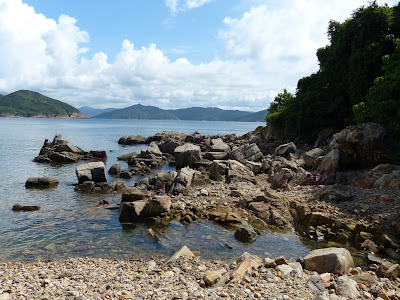
The first part of the headland stops at a small rocky beach, but if you look up at the foliage there are quite a few screw pine trees that line the area at the back.
The water in the shallows was very clear as you can see below. It seems that the visibility in HK waters (at least on the eastern side) has picked up significantly over the past couple of years. Certainly, as a diver, I have had days when visibility has been excellent by HK standards (>10M), and I wonder if part of the reason is because of the ban on bottom trawling introduced a few years ago? These pictures were snapped just at the far end of the aforementioned beach, just before you have to start climbing again.
As you round the second part of the headland the steepness of the rocks drops off a bit so it's much easier to walk. The hillside that you can see on the right in the top photo is the ridge of Ping Tok Hang Shan which forms part of the Lung Ha Wan Country Trail.
The second major barrier to progress was a deep cleft in the rock that proved a little difficult to navigate. Fortunately there is an area at the far end (away from the sea) that is passable as long as you don't mind sitting on your backside to get a proper foothold. The drop is only about 15 feet but it's certainly enough to break and ankle or leg, and given the rather secluded nature of the place, I don't think help will be that quick in coming...so be careful!
Finally, the destination is the beach on the south side of the headland. Back in the 1970's, this part of Lobster Bay was very popular with the film makers over at Shaw studios and several films have had scenes filmed at this spot. Andi's
Hong Kong Movie Tours blog has noted
several, and my own film blog has been at this southern point on at least one
occasion (so far).
Once at this beach (which, by the way, needs a jolly good clean up) there is a small path that leads to the back of the equestrian centre, so if you want to avoid all the hassle and adventure you can easily just walk here by passing through the stables and heading to the far end. But hey, I had several hours to kill so I thought I would try the scenic route.
Now, earlier on I mentioned the Lung Ha Wan Nature Trail, and this is one of the other worthwhile uses of your time if you are ever down this way. It starts right next to the CEEC and finishes at Tai Hang Tun at the very end of Clearwater Bay Road.
If you use public transport to go to Lobster Bay just to find the start of this trail you have two choices: you can either go to Hang Hau MTR and wait a long time for a taxi to take you to the end of Lung ha Wan Road (cost around $60) or you can catch the bus. The taxi route is expensive and you can sometimes be waiting a long time for a green cab at Hang Hau (I've waited 40 mins before!). The bus route gives you a couple of easier options - you can go to Diamond Hill MTR and hop on the #91 or you can head all the way down to Kwun Tong MTR and jump on the 103 green minibus. The latter tends to be a bit quicker. Anyway, both buses stop at the Tai Au Mun roundabout where you need to get off. However, getting the bus also means you automatically add an additional 2km to your walk because you will need to either walk down (or up) Lung Ha Wan Road depending on which direction you choose to tackle it. I did it clockwise which meant walking down Lung Ha Wan Road to the start of the trail, following the whole length of the trail over to Tai Hang Tun and then walking back to Tai Au Mun via Clearwater Bay Road. Either way you take, it forms a nice convenient loop (see below) of about 6km that begins and ends at the bus stops near Tai Au Mun roundabout.

Lung Ha Wan Trail incorporating Clearwater Bay and Lung Ha Wan Roads.
As an additional point of interest, Lung Ha Wan Road also contains one of HK's numerous rock carvings. They're marked from the road and you need to follow the steps down to see them. An interesting, if difficult to discern, brief side tour from the hike.
I must admit I had a hard time making out the markings properly, or at least the pattern they made, but they're worth a few minutes detour, plus you get some nice views from the ledge. Interestingly, this site doesn't have the usual perspex cover like I have seen at other rock carving sites.
Anyway, once again, the weather has been pretty damn fantastic this summer and we had a whole run of bright hot clear days from June almost through to August, so the views from the trail were quite spectacular.
One of the CEEC's paddocks at the bottom of the hill
There isn't much shade on the trail, just the odd tall tree here and there, most of it was fairly open. The downside is you get blasted with the sun, but the upside is you unfettered views out to sea.
Looking north towards inner Port Shelter
Trio Rock - a popular local dive site
Like most hikes in HK, the hard part is at the beginning as you head uphill and the easier party (although my knees may tend to disagree with me on that one) comes as you crest the hill and start the downhill walk into Tai Hang Tun.
We broke up the hike a little by stopping off for drinks at the shop in Tai Hang Tun and then wandering over to the kite flying area. If you are after some kite spare parts then this is the place to come because it has to be one of the most shamefully littered places I have ever been. People come in their thousands to fly their kites and when they go home it looks like they just dump all their stuff on the floor (or leave it to rot in the trees) and drive away - a sad indictment of the throwaway attitude of many people in HK. We ended up picking up a small workable kite and a reel plus a few hundred metres of kite wire for the kids.
The view from Tai Hang Tun looking over Clearwater Bay
Anyway, once refreshed it was a relatively short walk - though having to run the gauntlet of multiple MPV's parked on the pavement - down Clearwater Bay Road back to the roundabout and a bus trip home.


