Hongkong Bus Tours on the Cheap: #64K from Tai Po Market to Yuen Long History
One of the best ways to explore Hong Kong (or any place for that matter) is by using the bus. Sure the MTR system is often quicker and cheaper but nothing really beats a bus tour and what better way to do one than on a reasonably lengthy scheduled route that costs less than a bottle of Coke Zero at the 7-11.

So where to begin? If you arrived at Tai Po Market station via the MTR East Rail, you need to exit the turnstiles and look for the pedestrian subway/underpass that takes you to the bus terminus � it�s located right next to the Uptown Plaza escalators, so is easy to find.

At the bottom of the slope take the right hand branch and follow it around. On the way you�ll pass an exit on your left and another on your right, don�t take either of these but keep walking until you hit the second exit on the right hand side. Look closely at the picture below and you will be able to see the second exit in the distance just before the tiles turn red.


Just walk up the steps on the right hand side if this exit and you will see the 64K stop about 20 metres in front. You may have to wait a few minutes but the bus is reasonably regular so it probably won't be more than 10-15 minutes even if you have only just missed one.
Once on board sit back and enjoy the initial part of the journey through both the old and new parts of Tai Po. It�s possible to hop on the 64K later in its journey by catching it outside Tai Wo Station, but by then it could be quite full and you won�t get the pick of the seats (as I did when I was their age, my kids enjoy sitting at the front top of the bus, but these days the bars in front of the window tend to make my eyes go funny). Anyhow � all aboard, off we go and try not to be sick as the driver will invariably attempt full throttle whilst negotiating the tight bends and corners inside the bus station. Once daylight hits your face you know the initial puke-inducing whirlwind tour of the terminus is over and your epic HK bus journey has commenced.


After turning right at the first junction (above) we quickly pass Pan Chung New Village on the left which seems to be a bit of spillover from the original village of Pan Chung � Tai Po�s very own not-so-walled "walled" village. Further on and we zoom towards Wan Tau Street, the KCR railway bridge and the Tai Po Complex. Now, if you feel as though you are about to be decapitated Bond-style as the bus goes under the bridge, you could be forgiven.

The rail track has passed over this point ever since it was first built at the turn of the last century. When Wan Tau Street (the road we are currently on) was constructed a bridge/tunnel was built so traffic could pass underneath.

The problem was that with the introduction of large double-deck buses, the bridge was too low for them to get under. Unfortunately the bridge couldn't raised and the engineers instead had to dig under the bridge and lower the road instead - giving it a rather pronounced dip. A pragmatic solution to a tricky problem, only that the drainage here under the bridge is terrible and during heavy rainstorms the dip tends to look more like a swimming pool. My wife remembers an incident from her childhood when she actually saw a car floating under the bridge because it had tried to pass under the bridge when it was flooded. I haven't seen it get quite that bad yet, but it certainly gets deep.
Just past here is the bright and shiny new (at least compared to the rest of this part of town) Tai Po Market Complex. Here�s a partial snap I took a few years ago � the bus route travels towards the camera on the road at the bottom.


This building, sitting on the site of an old concrete playground, sticks out amongst the 70�s-era tenements surrounding it (from one of which I took the lower picture), but this modern sleek ship-like building has a whole bunch of great things inside including two levels of market stalls, a cooked food centre, a couple of levels of local Govt admin offices, a fantastic and modern library (beaten only, I feel, by Causeway Bay�s Central library) and two floors of sporting facilities.

Onward and left down Heung Sze Wui Street � a one way road named for the Tai Po Rural Committee HQ that was, until recently, found at the very end (Heung Sze means �rural matters�) on Po Heung Street. It�s been there for years and even showed up on some dodgy old Alan Tam music video back in the 80�s. However, just recently the HQ has upped-sticks and moved around the corner to an old school building on Shun Tak St.


The lower picture is actually the most recent and is a great example of how quickly things disappear and are replaced in Hong Kong. A huge complex of residential flats are being constructed as we speak and no doubt be following in the firmly established HK tradition of having a ridiculously stupid name such as Billionaire Heights, Bel-Air Apartments or perhaps just Royal Cheesy Bell-End Gardens.

Moving on down Po Heung Street � as you can see a kind of leafy tree-lined affair � and we go past some of the market area�s older streets on the left hand side. If you have read my brief introduction to Tai Po Market�s development, then you will know that these street were laid down as long ago as the 1920�s. They still largely contain very local shops run by local people which is why I like wandering around here - no signs of a takeover by homogeneous generic chain store jewellery shops yet. Anyway, moving swiftly on and we hit the junction with what was Tai Po Road but now goes by the name of Kwong Fuk Road.

Kwong Fuk Road was originally the final stage of the old Tai Po Road � the NT�s very first major artery which terminated at Kwong Fuk Bridge. Later in life the road extended over the bridge and onward into Fanling but when the Tai Po New Town development commenced the bridge was pedestrianised and the traffic re-routed over the newer Po Heung Bridge. It's the latter that we will cross in just a minute or two, but before then take note of the white and red buildings on the opposite side of the road.

The red/white buildings are part of the Plover Cove resettlement estate. This was constructed in the mid-60's the house the villagers (of the so-called Luk Heung or "6 Rural Villages") displaced by the creation of the Plover Cove reservoir to the north of Tai Po. Just opposite them on our left, as you start to cross the bridge, is the small school that was built as part of the village resettlement deal - the Luk Heung San Tsuen Gung Lap Hok Hau, which roughly translates as "Six Rural Villages New Village Public School".


Across the bridge we are entering Tai Po Centre (the "New Town" proper). Briefly, all this land was originally part of Tolo Harbour and was reclaimed in the 80�s to create new housing for the rather large and ever-increasing local population. A product of rather more 'modern planning', this part of Tai Po feels pretty much like any New Town and (to me, at least) lacks much of the character that can be found on the other side of the river bank, but hey, that�s just my humble opinion.

Down onto On Chee Road we go and we turn left towards Ting Kok Road. Not many people realise but actually Ting Kok Road is one of Tai Po�s earliest roads and originally ran along the western and northern coastline of Tolo Harbour. These days of course, most of it is now land-locked, but in a previous time everything east and south of the road was water.

As a result most of the buildings of interest are on the opposite side of the road. We don�t pass it on this trip but turning right at this junction will take us past the antique Tin Hau Temple. However, we are turning left and passing a couple more buildings of interest. The first is Sing Kung Cho Tong at 19 Ting Kok Rd. It's a private temple complex that has an affiliated T.C.M (Traditional Chinese Medicine) dispensary attached to it . Although this current building dates from 1990, its precursor was established in 1936 and was used by the Japanese Kempetai during the occupation for various interrogations and executions of the local Taipo population.

Just a few doors down at #9 is one of my favourite building in Tai Po, a sort of art deco designed shophouse. It has an old carpet shop on the ground floor and the Govt Home Affairs dept website lists its build year as 1945 which makes it possibly amongst the oldest private buildings in Tai Po. The chaps at Gwulo mentioned that (on the Buildings Department database) sometimes 1945 is used as a default build year when the construction year of a pre-war building is not known � so it is quite possible that this groovy looking thing is actually much older.

It�s not long before we are passing the fire station and local Govt offices and onward towards Tai Wo Station with the Lam Tsuen River (originally known as the Kwun Yam River) and its two ornately decorated bridges. The first one we pass is Kwong Fuk Bridge. The structure is relatively recent but the name harks back to the early days of the market.

The second bridge, not far away, is the Tai Wo bridge built in the same style with decorative red pillars but without the historical past of its nearby neighbour�s name. Finally you will see the railway bridge before the bus turns away and we begin our next part of the journey.

Tai Wo is a pretty drab looking place to be honest. It�s a large Govt housing estate finished in a very uninspiring beige and it is just...well, fugly! Before the new town was created the area was largely rice paddies as well as the site for the local abattoir, and the extended Tai Po Road cut through the middle of it on its way to Fanling. The bus goes under the station building and follows the same route towards Fanling before turning off to Lam Tsuen.

Once beyond the station we join what is now called Sui Wai Road - named after a nearby village - but is the later addition to the Tai Po Road that formed part of Route 9 - a circular route around the New Territories that started and ended in Kowloon.

This is where the journey starts to get a bit more picturesque as we begin our journey into the countryside. On the left we have a couple of modern residential developments known as Parc Versailles and Tai Po Garden and along the right runs the rail track on its journey from Tai Wo to Fanling.


Behind the track is a new village house development called �The Wonderland�. The only thing I �wonder� about is who is crazy enough to fork out for a brand new house that sits right next to a noisy train line. They should have just called this place �The Sidings� and had done with it. Anyway, I recently found out that the land it sits on used to house a popular 'amusement' park called Greenville Park (????). It was fronted by a huge stone archway and had a popular restaurant inside as well as other amusements park...thingies. It seems to have opened in the late 40's and managed to stay in business throughout the 50's and 60's under various guises (park, restaurant, park/restaurant etc). I'm not sure of when it was demolished but it sounds as though it was still around in the late 70's and possibly the early 80's.


Unfortunately for visitors, this area has seen a lot of major construction due to the creation of some extra lanes of the Fanling Highway. The whole area was covered in false-work as the extra lanes were being poured into place. Most of it seems to have been done now, but we're not sticking around here for too long anyway because once across the roundabout we are into the rather nicer environment of the Lam Tsuen valley and Lam Kam Road.


Leaving the roundabout we start up Lam Kam Road, the main thoroughfare through the Lam Tsuen valley. Now, I have to admit that this part of Hong Kong is one of the prettiest in the territory and this road, that runs the length of the Lam Tsuen valley and its 26 villages, is a great place to come and see some rural countryside. The bit we are now on runs for about 5 km in a southwesterly direction and there is staggering scenery on both sides.


This road will be familiar with anyone who has already visited the Lam Tsuen Wishing Tree � the first major sight along here. The Wishing Tree�s story is a perfect example of how to become a victim of your own success or "death by exploitation".

Originally the wish throwing (writing a wish on a piece of paper, tying it to a kumquat and then chucking it into the tree in the hope that it stays hooked on a branch) was restricted to Lunar New Year. Unfortunately it was a good earner for the villagers and evolved into a year-round activity. The poor tree was constantly bombarded and became overburdened with wishes, eventually collapsing (in 2005) onto a passerby's head. So what do we have now? Well, the tree is knackered. It will take decades to recover. But luckily for all of us (but more importantly, the villagers) a new tree has emerged as the recipient of all those wishes...:-/

There�s a lesson to be learnt here, but if you need me to spell it out for you then you're probably the sort of person that would throw a piece of litter into a tree in the hope that it would grant you a wish :-) Anyway, wish throwing costs money and isn't obligatory. If you don�t want to partake then the antique Tin Hau temple and super expensive (to make, not to use) public toilets are worth checking out on their own (yes, you did read that last bit correctly!).
Moving on and straight ahead you will be able to see Hong Kong�s highest peak: Tai Mo Shan. Being tall has its advantages, in Tai Mo Shan�s case it means that we can see it from pretty much anywhere in HK�on a clear day, that is. In this case, the Lam Tsuen valley sits at the bottom of the big mountain�s foothills, so it�s no surprise that it dominates the scenery here.

The transmitters on top of the mountain are mainly related to the Civil Aviation Department's radar station (for guiding and keeping tabs on aircraft), but it was recently discovered that the Govt had allowed the PLA to build a listening post up there, much to the chagrin of the locals who believe the land should be open to the public. We will return to Tai Mo Shan later from a different angle, but for the time being just sit back and watch some fantastic countryside roll by.


As you sit back try to imagine what this place looked like when the British took charge of the NT in 1899 and had to fight off the local militia. The 6 day war not only happened in and around Tai Po Market but also went up the Lam Tsuen valley as the British troops pursued the militia towards the Kam Tin plain along, what was then, a small footpath. The footpath has now been replaced by the Lam Kam Road (the road we are currently on) but thankfully the mountains remain as they always have been: green and spectacular.


Don�t relax too much though because you may also be tempted to hop off at Ng Tung Chai to visit either the waterfalls or the Man Tak Yuen temple�or both. The buses usually have a bilingual display at the front of the bus as well as audio announcements so missing the various stops � as long as you are attentive it shouldn�t be a problem. The Wishing Tree at Fong Ma Po, Ng Tung Chai and Kadoorie Farm � the 3 most popular stops along Lam Kam Road � are all announced in both Cantonese and English with accompanying textual display, so don�t fret.

Speaking of Kadoorie Farm, this is actually just one stop up from Ng Tung Chai and is hard to miss (unlike Ng Tung Chai which is actually located up a side road) because it�s right on the roadside.

You can hop off if you like � but don't forget this is not a hop-on-hop-off bus. If you get off now, then boarding alter will mean you have to pay whatever fare is displayed on the meter. The road gets quite steep uphill as we pass Kadoorie and this signals the end of the valley because once we crest the hill we will get views of Kam Tin and Yuen Long across the plain (and it really is flat down there) towards the Chinese border.


You�ll know when you are out of Lam Tsuen because not only will you be heading downhill but at the bottom is the roundabout that joins Lam Kam Road with Route TWISK. I�ll save the latter for another DIY bus tour at a later date, but it�s worth knowing that this ex-military road is one of the most incredible in the territory. It links Tsuen Wan with Sek Kong, hence the name TWISK. By all means get off here and catch the #51 bus into Tsuen Wan if you feel you have had enough of the 64K.

Just past the roundabout is the small village of Sheung Tsuen. Anonymous except for the fact that it was the site of the last major push by the Chinese militia during the 6 day war. Speaking of wars, there is also a commemorative obelisk here (see picture above), remembering the valiant efforts of the communist guerrillas during the Japanese occupation. It was installed just prior to the handover as the local villagers were suddenly and inexplicably overcome with patriotic fervour. Sadly, no one in officialdom took any any notice. However, it's a worthy monument to the brave guerrillas, many of whom were captured, tortured and summarily executed by the Japanese.
Moving on and we have now turned onto the Kam Sheung Road and sadly, what could be a wonderful and picturesque part of the NT is marred by the proliferation of light industry and general lack of care for the environment.
One of the Govt�s great failings in the NT is to sort out some of the complete and absolute unsightliness that has grown here. As you travel down Kam Sheung Road the one thing you will notice is the number of wrecker yards, heavy plant hire, container storage and assorted rusty corrugated iron-walled compounds where things are just left to rot and rust. It�s a real shame because there are some absolute gems here in the form of old houses, temples and the nice scenery that is still here, but hidden under all the crap. Here is a more mild example.

Actually, if you look at the picture above you will notice our old friend Tai Mo Shan in the background and far left is the distinct hump of Kwun Yam Shan. We did actually pass right by Kwun Yam Shan earlier � Kadoorie farm is built on its lower slopes � but it�s hard to see its pointy shape when you are that close.


Before we leave Kam Sheung Road we make a final stop along the way at the eponymous train station. Here is where the bus route conveniently intersects with the West Rail line.

One of the things that is making this part of the NT more appealing to live in (despite all the scrap metal yards) is the convenience of the West Rail line. From here you can be in Kowloon within 20 minutes. Or if you fancy heading a bit further west than the 64K will take you then it is quick (probably 10-15 minutes) to make it all the way to Tuen Mun from here. So feel free if you have had enough already to hop off the bus and head back home on the train. Or if you are staying in Kowloon and want to join the 64K at this point you can do that too because it also comes here on its returned journey back to Tai Po - just pay attention to the destination on the front so you don't get on the wrong direction. Anyway, for those of us carrying on into Yuen Long we will now start to hit the outskirts of this rather large old market town (now New Town).

Sadly my knowledge of Yuen Long is rather lacking. I can talk for hours about Tai Po and can pull out hundreds of stupid inconsequential facts about the place but when it comes to Yuen Long I'm fairly ignorant, so it's probably a good job that the journey is almost finished.
However, before we get to our destination, as we approach the famous Pok Oi Hospital, keep an eye open for what looks like a large temple complex on its western side (the bus goes right past there in a weird doubling-back kinda loop thang.

You can see it poking just over the bushes there. In fact it's not a temple but a large traditional style residential complex built by a local Hakka man in 1932. It�s called Pun Uk (literally �Pun�s House�) and I am glad to say it has a Grade 1 listing � although to be honest with its age and architecture it should have been made a monument a long time ago (first recommended in 1979). Why the Govt are dragging their feet I can only guess there are powerful vested interests that they are scared of annoying. Let�s face it, the Govt is scared of pretty much anyone these days. Interestingly the builder of the house was a major benefactor of the original Pok Oi Hospital � which may explain its immediate proximity. I am also reliably informed that this was also the Japanese military HQ for Yuen Long during the occupation. I�m sure its walls could tell many stories.
Nearing the end of this journey we turn onto the famous Castle Peak Road. This is the same road that originally linked up with the Tai Po Road to form the road loop of the NT I mentioned earlier.


This road in Yuen Long must be one of the busiest in the NT. It is packed full of all kinds of shops and also plays host to a great little transport system called the LRT (Light Rail Transit). Cheap, convenient and fun to ride it�s a great way to get around the western part of the NT. Anyway, that is pretty much it for our bus tour because when you arrive in this place�

Then, you have reached the terminus. So get off and have a wander � Yuen Long, like Tai Po has a good mixture of old and new to see so it is easy to spend quite some time exploring stuff (I can personally recommend a trip to the Central park with its open pagoda � especially if you have kids).
You have several choices for getting back home: the same bus back to Tai Po, West Rail from Long Ping Station (situated just north of the bus terminus you got off at) towards either Kowloon or Tuen Mun via West Rail, or LRT down to Tuen Mun.
It is actually quite feasible to cover a large area of the territory on just a few carefully selected routes, and here is one of them - the 64K bus from Tai Po Market Station to Yuen Long. A route that takes in both the new and old of Tai Po, the lush scenery of the Lam Tsuen valley as well as the rather shambolic (but sometimes picturesque) tumbledown nature of Kam Tin's various container parks :-/
This route in particular has some well-trodden tourist spots on the way including the famous (but now rather naff) Fong Ma Po Wishing Tree, Ng Tung Chai waterfalls and Kadoorie Botanical Farm. It also has a few stops along the way where you can make a further detour if you don't fancy going all the way into Yuen Long. I've pointed them out as and when so just keep reading.The great thing about this ride is also that you can hop off at either end, go for a wander, and then return and catch the bus all the way back to your starting place. Even the most timid of visitors should have no problem wandering outside their comfort zones with such an easy trip, the only bit of thought needed is deciding which end of the route you wish to catch the bus from: Tai Po or Yuen Long. Either way is fine, the route I've described is the same, it's just that I did it from TP - YL direction.
The above Google Earth grab shows the approximate route the bus takes. The distance is actually less than 9 miles as the crow flies, but this being Hong Kong with its usually hilly and mountainous terrain means the bus mileage is around double that. The trip can be quick ( one way 45 mins) if the traffic is kind, or can stretch to 90 mins if the traffic gets busy. Either way, getting to and from your start/end points will add another hour onto the journey so this is something that can be done in a morning or afternoon.
So where to begin? If you arrived at Tai Po Market station via the MTR East Rail, you need to exit the turnstiles and look for the pedestrian subway/underpass that takes you to the bus terminus � it�s located right next to the Uptown Plaza escalators, so is easy to find.
Tai Po Market Station subway access to Bus terminus
At the bottom of the slope take the right hand branch and follow it around. On the way you�ll pass an exit on your left and another on your right, don�t take either of these but keep walking until you hit the second exit on the right hand side. Look closely at the picture below and you will be able to see the second exit in the distance just before the tiles turn red.
Here�s the exit you want, the sign on the right points you to the 64K (see below).
Just walk up the steps on the right hand side if this exit and you will see the 64K stop about 20 metres in front. You may have to wait a few minutes but the bus is reasonably regular so it probably won't be more than 10-15 minutes even if you have only just missed one.
Once on board sit back and enjoy the initial part of the journey through both the old and new parts of Tai Po. It�s possible to hop on the 64K later in its journey by catching it outside Tai Wo Station, but by then it could be quite full and you won�t get the pick of the seats (as I did when I was their age, my kids enjoy sitting at the front top of the bus, but these days the bars in front of the window tend to make my eyes go funny). Anyhow � all aboard, off we go and try not to be sick as the driver will invariably attempt full throttle whilst negotiating the tight bends and corners inside the bus station. Once daylight hits your face you know the initial puke-inducing whirlwind tour of the terminus is over and your epic HK bus journey has commenced.
Out of the bus station�
�and off we go. Wan Tau Tong straight ahead, but we turn right
After turning right at the first junction (above) we quickly pass Pan Chung New Village on the left which seems to be a bit of spillover from the original village of Pan Chung � Tai Po�s very own not-so-walled "walled" village. Further on and we zoom towards Wan Tau Street, the KCR railway bridge and the Tai Po Complex. Now, if you feel as though you are about to be decapitated Bond-style as the bus goes under the bridge, you could be forgiven.
Pan Chung New Village on the left, Tai Po Complex ahead
The rail track has passed over this point ever since it was first built at the turn of the last century. When Wan Tau Street (the road we are currently on) was constructed a bridge/tunnel was built so traffic could pass underneath.
DUCK!!
The problem was that with the introduction of large double-deck buses, the bridge was too low for them to get under. Unfortunately the bridge couldn't raised and the engineers instead had to dig under the bridge and lower the road instead - giving it a rather pronounced dip. A pragmatic solution to a tricky problem, only that the drainage here under the bridge is terrible and during heavy rainstorms the dip tends to look more like a swimming pool. My wife remembers an incident from her childhood when she actually saw a car floating under the bridge because it had tried to pass under the bridge when it was flooded. I haven't seen it get quite that bad yet, but it certainly gets deep.
Just past here is the bright and shiny new (at least compared to the rest of this part of town) Tai Po Market Complex. Here�s a partial snap I took a few years ago � the bus route travels towards the camera on the road at the bottom.
This building, sitting on the site of an old concrete playground, sticks out amongst the 70�s-era tenements surrounding it (from one of which I took the lower picture), but this modern sleek ship-like building has a whole bunch of great things inside including two levels of market stalls, a cooked food centre, a couple of levels of local Govt admin offices, a fantastic and modern library (beaten only, I feel, by Causeway Bay�s Central library) and two floors of sporting facilities.
Great Day Restaurant ahead � must be Heung Sze Wui St
Onward and left down Heung Sze Wui Street � a one way road named for the Tai Po Rural Committee HQ that was, until recently, found at the very end (Heung Sze means �rural matters�) on Po Heung Street. It�s been there for years and even showed up on some dodgy old Alan Tam music video back in the 80�s. However, just recently the HQ has upped-sticks and moved around the corner to an old school building on Shun Tak St.
Tai Po Rural Affairs Committee � now you see it�
�now you don�t!
The lower picture is actually the most recent and is a great example of how quickly things disappear and are replaced in Hong Kong. A huge complex of residential flats are being constructed as we speak and no doubt be following in the firmly established HK tradition of having a ridiculously stupid name such as Billionaire Heights, Bel-Air Apartments or perhaps just Royal Cheesy Bell-End Gardens.
Tree-lined Po Heung Street
Moving on down Po Heung Street � as you can see a kind of leafy tree-lined affair � and we go past some of the market area�s older streets on the left hand side. If you have read my brief introduction to Tai Po Market�s development, then you will know that these street were laid down as long ago as the 1920�s. They still largely contain very local shops run by local people which is why I like wandering around here - no signs of a takeover by homogeneous generic chain store jewellery shops yet. Anyway, moving swiftly on and we hit the junction with what was Tai Po Road but now goes by the name of Kwong Fuk Road.
Kwong Fuk Road was originally the final stage of the old Tai Po Road � the NT�s very first major artery which terminated at Kwong Fuk Bridge. Later in life the road extended over the bridge and onward into Fanling but when the Tai Po New Town development commenced the bridge was pedestrianised and the traffic re-routed over the newer Po Heung Bridge. It's the latter that we will cross in just a minute or two, but before then take note of the white and red buildings on the opposite side of the road.
The red/white buildings are part of the Plover Cove resettlement estate. This was constructed in the mid-60's the house the villagers (of the so-called Luk Heung or "6 Rural Villages") displaced by the creation of the Plover Cove reservoir to the north of Tai Po. Just opposite them on our left, as you start to cross the bridge, is the small school that was built as part of the village resettlement deal - the Luk Heung San Tsuen Gung Lap Hok Hau, which roughly translates as "Six Rural Villages New Village Public School".
The Luk Heung New Village Public School
Over the Po Heung Bridge, Tai Po Centre dead ahead
View from the bridge � can't take any more.
Across the bridge we are entering Tai Po Centre (the "New Town" proper). Briefly, all this land was originally part of Tolo Harbour and was reclaimed in the 80�s to create new housing for the rather large and ever-increasing local population. A product of rather more 'modern planning', this part of Tai Po feels pretty much like any New Town and (to me, at least) lacks much of the character that can be found on the other side of the river bank, but hey, that�s just my humble opinion.
Leafy but lacking character
Down onto On Chee Road we go and we turn left towards Ting Kok Road. Not many people realise but actually Ting Kok Road is one of Tai Po�s earliest roads and originally ran along the western and northern coastline of Tolo Harbour. These days of course, most of it is now land-locked, but in a previous time everything east and south of the road was water.
Approaching Ting Kok Road
As a result most of the buildings of interest are on the opposite side of the road. We don�t pass it on this trip but turning right at this junction will take us past the antique Tin Hau Temple. However, we are turning left and passing a couple more buildings of interest. The first is Sing Kung Cho Tong at 19 Ting Kok Rd. It's a private temple complex that has an affiliated T.C.M (Traditional Chinese Medicine) dispensary attached to it . Although this current building dates from 1990, its precursor was established in 1936 and was used by the Japanese Kempetai during the occupation for various interrogations and executions of the local Taipo population.
Sing Kung Cho Tong behind the red wall
Just a few doors down at #9 is one of my favourite building in Tai Po, a sort of art deco designed shophouse. It has an old carpet shop on the ground floor and the Govt Home Affairs dept website lists its build year as 1945 which makes it possibly amongst the oldest private buildings in Tai Po. The chaps at Gwulo mentioned that (on the Buildings Department database) sometimes 1945 is used as a default build year when the construction year of a pre-war building is not known � so it is quite possible that this groovy looking thing is actually much older.
Pre-1945 Art deco shophouse on Ting Kok Rd
It�s not long before we are passing the fire station and local Govt offices and onward towards Tai Wo Station with the Lam Tsuen River (originally known as the Kwun Yam River) and its two ornately decorated bridges. The first one we pass is Kwong Fuk Bridge. The structure is relatively recent but the name harks back to the early days of the market.
The current Kwong Fuk Bridge � historical in name at least
The second bridge, not far away, is the Tai Wo bridge built in the same style with decorative red pillars but without the historical past of its nearby neighbour�s name. Finally you will see the railway bridge before the bus turns away and we begin our next part of the journey.
Tai Wo Bridge with the railway bridge in the background
Tai Wo is a pretty drab looking place to be honest. It�s a large Govt housing estate finished in a very uninspiring beige and it is just...well, fugly! Before the new town was created the area was largely rice paddies as well as the site for the local abattoir, and the extended Tai Po Road cut through the middle of it on its way to Fanling. The bus goes under the station building and follows the same route towards Fanling before turning off to Lam Tsuen.
Tai Wo � just move along now, nothing to see here
Once beyond the station we join what is now called Sui Wai Road - named after a nearby village - but is the later addition to the Tai Po Road that formed part of Route 9 - a circular route around the New Territories that started and ended in Kowloon.
Sui Wai Road dead ahead, Lam Tsuen ridge line in the distance
This is where the journey starts to get a bit more picturesque as we begin our journey into the countryside. On the left we have a couple of modern residential developments known as Parc Versailles and Tai Po Garden and along the right runs the rail track on its journey from Tai Wo to Fanling.
Sui Wai Road
Parc Versailles on the left
Rail line, train and �The Wonderland� behind it
Behind the track is a new village house development called �The Wonderland�. The only thing I �wonder� about is who is crazy enough to fork out for a brand new house that sits right next to a noisy train line. They should have just called this place �The Sidings� and had done with it. Anyway, I recently found out that the land it sits on used to house a popular 'amusement' park called Greenville Park (????). It was fronted by a huge stone archway and had a popular restaurant inside as well as other amusements park...thingies. It seems to have opened in the late 40's and managed to stay in business throughout the 50's and 60's under various guises (park, restaurant, park/restaurant etc). I'm not sure of when it was demolished but it sounds as though it was still around in the late 70's and possibly the early 80's.
Approaching the Fanling Highway Flyover
Unfortunately for visitors, this area has seen a lot of major construction due to the creation of some extra lanes of the Fanling Highway. The whole area was covered in false-work as the extra lanes were being poured into place. Most of it seems to have been done now, but we're not sticking around here for too long anyway because once across the roundabout we are into the rather nicer environment of the Lam Tsuen valley and Lam Kam Road.
Lam Kam Roundabout
Off to Lam Tsuen
Leaving the roundabout we start up Lam Kam Road, the main thoroughfare through the Lam Tsuen valley. Now, I have to admit that this part of Hong Kong is one of the prettiest in the territory and this road, that runs the length of the Lam Tsuen valley and its 26 villages, is a great place to come and see some rural countryside. The bit we are now on runs for about 5 km in a southwesterly direction and there is staggering scenery on both sides.
Lam Kam Road
This road will be familiar with anyone who has already visited the Lam Tsuen Wishing Tree � the first major sight along here. The Wishing Tree�s story is a perfect example of how to become a victim of your own success or "death by exploitation".
Fong Ma Po � turn off for the naff wishing tree
Originally the wish throwing (writing a wish on a piece of paper, tying it to a kumquat and then chucking it into the tree in the hope that it stays hooked on a branch) was restricted to Lunar New Year. Unfortunately it was a good earner for the villagers and evolved into a year-round activity. The poor tree was constantly bombarded and became overburdened with wishes, eventually collapsing (in 2005) onto a passerby's head. So what do we have now? Well, the tree is knackered. It will take decades to recover. But luckily for all of us (but more importantly, the villagers) a new tree has emerged as the recipient of all those wishes...:-/
Destroyed tree on the right
There�s a lesson to be learnt here, but if you need me to spell it out for you then you're probably the sort of person that would throw a piece of litter into a tree in the hope that it would grant you a wish :-) Anyway, wish throwing costs money and isn't obligatory. If you don�t want to partake then the antique Tin Hau temple and super expensive (to make, not to use) public toilets are worth checking out on their own (yes, you did read that last bit correctly!).
Moving on and straight ahead you will be able to see Hong Kong�s highest peak: Tai Mo Shan. Being tall has its advantages, in Tai Mo Shan�s case it means that we can see it from pretty much anywhere in HK�on a clear day, that is. In this case, the Lam Tsuen valley sits at the bottom of the big mountain�s foothills, so it�s no surprise that it dominates the scenery here.
Tai Mo Shan and its transmitters
The transmitters on top of the mountain are mainly related to the Civil Aviation Department's radar station (for guiding and keeping tabs on aircraft), but it was recently discovered that the Govt had allowed the PLA to build a listening post up there, much to the chagrin of the locals who believe the land should be open to the public. We will return to Tai Mo Shan later from a different angle, but for the time being just sit back and watch some fantastic countryside roll by.
As you sit back try to imagine what this place looked like when the British took charge of the NT in 1899 and had to fight off the local militia. The 6 day war not only happened in and around Tai Po Market but also went up the Lam Tsuen valley as the British troops pursued the militia towards the Kam Tin plain along, what was then, a small footpath. The footpath has now been replaced by the Lam Kam Road (the road we are currently on) but thankfully the mountains remain as they always have been: green and spectacular.
Don�t relax too much though because you may also be tempted to hop off at Ng Tung Chai to visit either the waterfalls or the Man Tak Yuen temple�or both. The buses usually have a bilingual display at the front of the bus as well as audio announcements so missing the various stops � as long as you are attentive it shouldn�t be a problem. The Wishing Tree at Fong Ma Po, Ng Tung Chai and Kadoorie Farm � the 3 most popular stops along Lam Kam Road � are all announced in both Cantonese and English with accompanying textual display, so don�t fret.
Ng Tung Chai (in Chinese)
Speaking of Kadoorie Farm, this is actually just one stop up from Ng Tung Chai and is hard to miss (unlike Ng Tung Chai which is actually located up a side road) because it�s right on the roadside.
Kadoorie Farm entrance
You can hop off if you like � but don't forget this is not a hop-on-hop-off bus. If you get off now, then boarding alter will mean you have to pay whatever fare is displayed on the meter. The road gets quite steep uphill as we pass Kadoorie and this signals the end of the valley because once we crest the hill we will get views of Kam Tin and Yuen Long across the plain (and it really is flat down there) towards the Chinese border.
You�ll know when you are out of Lam Tsuen because not only will you be heading downhill but at the bottom is the roundabout that joins Lam Kam Road with Route TWISK. I�ll save the latter for another DIY bus tour at a later date, but it�s worth knowing that this ex-military road is one of the most incredible in the territory. It links Tsuen Wan with Sek Kong, hence the name TWISK. By all means get off here and catch the #51 bus into Tsuen Wan if you feel you have had enough of the 64K.
Just past the roundabout is the small village of Sheung Tsuen. Anonymous except for the fact that it was the site of the last major push by the Chinese militia during the 6 day war. Speaking of wars, there is also a commemorative obelisk here (see picture above), remembering the valiant efforts of the communist guerrillas during the Japanese occupation. It was installed just prior to the handover as the local villagers were suddenly and inexplicably overcome with patriotic fervour. Sadly, no one in officialdom took any any notice. However, it's a worthy monument to the brave guerrillas, many of whom were captured, tortured and summarily executed by the Japanese.
Moving on and we have now turned onto the Kam Sheung Road and sadly, what could be a wonderful and picturesque part of the NT is marred by the proliferation of light industry and general lack of care for the environment.
One of the Govt�s great failings in the NT is to sort out some of the complete and absolute unsightliness that has grown here. As you travel down Kam Sheung Road the one thing you will notice is the number of wrecker yards, heavy plant hire, container storage and assorted rusty corrugated iron-walled compounds where things are just left to rot and rust. It�s a real shame because there are some absolute gems here in the form of old houses, temples and the nice scenery that is still here, but hidden under all the crap. Here is a more mild example.
This isn�t too bad to look at, but it does get worse
Actually, if you look at the picture above you will notice our old friend Tai Mo Shan in the background and far left is the distinct hump of Kwun Yam Shan. We did actually pass right by Kwun Yam Shan earlier � Kadoorie farm is built on its lower slopes � but it�s hard to see its pointy shape when you are that close.
a nicer part of Kam Sheung Road
and a rather large rural homestead dating from 1967
Before we leave Kam Sheung Road we make a final stop along the way at the eponymous train station. Here is where the bus route conveniently intersects with the West Rail line.
One of the things that is making this part of the NT more appealing to live in (despite all the scrap metal yards) is the convenience of the West Rail line. From here you can be in Kowloon within 20 minutes. Or if you fancy heading a bit further west than the 64K will take you then it is quick (probably 10-15 minutes) to make it all the way to Tuen Mun from here. So feel free if you have had enough already to hop off the bus and head back home on the train. Or if you are staying in Kowloon and want to join the 64K at this point you can do that too because it also comes here on its returned journey back to Tai Po - just pay attention to the destination on the front so you don't get on the wrong direction. Anyway, for those of us carrying on into Yuen Long we will now start to hit the outskirts of this rather large old market town (now New Town).
Yuen Long here we come
Sadly my knowledge of Yuen Long is rather lacking. I can talk for hours about Tai Po and can pull out hundreds of stupid inconsequential facts about the place but when it comes to Yuen Long I'm fairly ignorant, so it's probably a good job that the journey is almost finished.
However, before we get to our destination, as we approach the famous Pok Oi Hospital, keep an eye open for what looks like a large temple complex on its western side (the bus goes right past there in a weird doubling-back kinda loop thang.
You can see it poking just over the bushes there. In fact it's not a temple but a large traditional style residential complex built by a local Hakka man in 1932. It�s called Pun Uk (literally �Pun�s House�) and I am glad to say it has a Grade 1 listing � although to be honest with its age and architecture it should have been made a monument a long time ago (first recommended in 1979). Why the Govt are dragging their feet I can only guess there are powerful vested interests that they are scared of annoying. Let�s face it, the Govt is scared of pretty much anyone these days. Interestingly the builder of the house was a major benefactor of the original Pok Oi Hospital � which may explain its immediate proximity. I am also reliably informed that this was also the Japanese military HQ for Yuen Long during the occupation. I�m sure its walls could tell many stories.
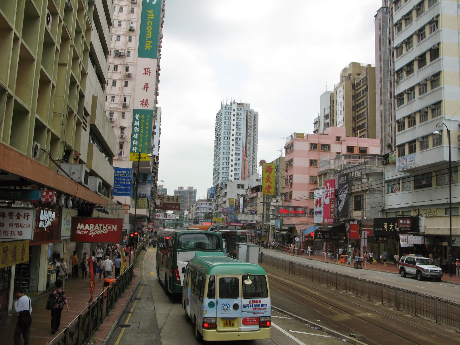
Nearing the end of this journey we turn onto the famous Castle Peak Road. This is the same road that originally linked up with the Tai Po Road to form the road loop of the NT I mentioned earlier.
This road in Yuen Long must be one of the busiest in the NT. It is packed full of all kinds of shops and also plays host to a great little transport system called the LRT (Light Rail Transit). Cheap, convenient and fun to ride it�s a great way to get around the western part of the NT. Anyway, that is pretty much it for our bus tour because when you arrive in this place�
Then, you have reached the terminus. So get off and have a wander � Yuen Long, like Tai Po has a good mixture of old and new to see so it is easy to spend quite some time exploring stuff (I can personally recommend a trip to the Central park with its open pagoda � especially if you have kids).
You have several choices for getting back home: the same bus back to Tai Po, West Rail from Long Ping Station (situated just north of the bus terminus you got off at) towards either Kowloon or Tuen Mun via West Rail, or LRT down to Tuen Mun.


