Hongkong Bus Tours on the Cheap � #271 from Tsim Sha Tsui to Tai Po (and back again) History
Despite the fact that Hong Kong's MTR system is usually lauded by anyone and everyone, my number one preferred way of navigating this place is by bus. Sure, it's not necessarily as convenient or speedy (or even as cheap for that matter) but it's certainly a great way to familiarise yourself with the general layout of things and take in some sights that you may not necessarily get to see stuck underground. So, following on from a post I did a while back for the 64K bus route from Tai Po to Yuen Long, here is one that may be more useful to anyone staying in Kowloon but wishing to head into the New Territories for a few hours. It's the #271 bus from Nathan Road to Fu Heng Estate in Tai Po.


The wait for the bus is usually <10mins. I haven't checked the price recently but it was less than $10 when I first wrote this post...erm...4 years ago! Kids pay half afre, as usual, and under 4's get to ride for free. Here�s a few of the sites you will get to see as you whiz past at the usual HK bus speed (I believe William Shatner used to call it Warp Factor 10) such as the 100 year old banyan�s for starters (minus some that have been chopped down due to instability). Other than the trees there is the odd notable sight of the HQ for the Antiquities and Monuments office - a red brick building that was once the Kowloon British School - and St Andrew's Church. The latter is currently having its antique front wall being replaced by an ill-advised glass see through panel.


At the junction with Waterloo Road the bus turns right on to said road and up towards the outskirts of Ho Man Tin. The action slows down a bit on Waterloo Road, but you can still see the very strangely shaped (and strangely named) Truth Lutheran Church as well as the famous Kowloon Wah Yan College and Kwong Wah Hospital. If you've read Martin Booth�s memoir Gwei Lo (US name: Goldenboy) should recognise the name of this road because it�s where the Four Seas Hotel used to stand. The building standing on that site now is the Kowloon Metropark Hotel. This happens to be the origin of the SARS virus in HK - brought there by a Mainland Chinese doctor and then spread around the globe from here in 2003. Not surprisingly the hotel group changed its name from Metropole to Metropark soon afterwards in an attempt to deflect some of the bad publicity.


At the end of Waterloo Road is the art deco Kowloon offices of C.L.P (China Light and Power). C.L.P is owned by the same family who own The Peninsula Hotel (amongst others), The Kadoories, am Iraqi Jewish family with links to HK and Shanghai stretching back many years. When I first posted this article several years ago I made a throwaway comment about a massive uproar ensuing if the building should ever be knocked down. It seems that it was a prophetic remark because demolition work started on the newer west wing of the building a couple of years ago. Thankfully the wing with the clock tower, as seen below, is set to stay.


C.L.P is actually the monopoly electricity supplier for Kowloon and the NT (Li Ka Shing owns the monopoly that supplies HK Island � HK Electric). The Kadoorie name can also be found on Kadoorie Avenue � the road where Leslie Cheung used to live (and where Andy Lau still does) and where one of HK�s more famous boys schools is situated: Diocesan Boy�s School as well as the famous experimental farm located in Lam Tsuen, Tai Po.
Notice the big red and yellow cube in the centre left of the upper picture? That's the emblem for the district we are about to enter - Kowloon City District. We've just been in and now left Yau Tsim Mong District (which as the name suggests, includes Yau Ma Tei, Tsim Sha Tsui and Mongkok).


This was the famous location of one of JC's mad Japanese fans killing herself by ingesting poison after breaking into the property and for a time I figured he had it knocked down to stop people from trophy hunting etc. However, it turns out that the building was structurally unsafe - it was built to Jackie's very own design...! - and had to come down before it toppled like a house of cards. I did get some pictures before it went but I'll save those for another post.
Moving over to the opposite side of the road is what is now known as Kowloon East Barracks. Pre-1997 this place was known as Osborn Barracks, one of the larger accommodation centres for the British garrison's married members. The barracks were named after the Canadian soldier, John Robert Osborn, who saved his fellow soldiers from a Japanese grenade by throwing himself on top of it during the Battle for HK in December 1941. He was awarded a posthumous Victoria Cross. There is a statue dedicated to him in Hong Kong Park that many tourists mistakenly believe is an image of him, but in fact it actually depicts a WW1 soldier and was donated by the famous Eu family from their estate at Eucliffe (a long gone castle-like property in Repulse Bay). Before the statue was moved to the park, it was sited at these barracks.


Further along the road it starts to slope up and this is where we are on the lower slopes of the Kowloon mountains with Lion Rock ahead and beacon Hill to the left. Nearby is Beacon Hill Road and the scene of Bruce Lee's death in Betty Ting Pei's apartment in 1973 and on the right we pass the apartment blocks that sit on Broadcast Drive. Once the home of various broadcasters including TVB, ATV (RTV/Rediffusion) and RTHK, only RTHK has managed to stick around and the sites of the other two companies have since been redeveloped into luxury housing. The snap below shows Peninsula Heights that stands on the former TVB studio lot at #63 Broadcast Drive.

After passing the toll booths you can look up to your right and see the famous Amah rock (Mong Fu Sek in Cantonese which means �staring after husband rock�). The legend is part of local folklore and is quoted in all the tour books � even my kids learned about it in kindergarten. It's well worth a trip up there if you get the chance (and reasonably easy to get to) but even from the bus you get a good glimpse. Sadly, I was a bit slow on the shutter and missed the opportunity for a better shot, this one will have to do.

Past here its a slow descent into Shatin valley, not much to see until we cross the �river� (the body of water formerly known as Shatin Sea) and you can see a building I mentioned previously in my Shatin -> Tai Po walk post. Yes, it�s the 'pretending-to-but-not-really-floating' floating restaurant.

We�re now on the home straight (for 6 years it literally was for me because I lived in Tai Po) and we join the Tolo Highway as it motors past the Shatin racecourse (I won HK$1800 there once � sheer fluke though I have to add) and further on down past the Chinese University of HK which sits on the hillside on the western side of the valley. (incidentally the remaining shots are all from Streetview because my trusty camera ran out of power *sigh*).


You can just see some of the University buildings peeking out from the hilltop above. Can you see the rather large-bore pipe that is running along the side of the highway? I believe this is the pipe that carries water taken from Plover Cove reservoir down towards Kowloon (I did see a schematic once but can�t remember where the water ends up before it gets put into the mains system?).
You�ll also notice a rather swish looking development just past it called Deerhill Bay. It sits on the former site of St Christopher�s Home � an orphanage run by the Anglican Church. The site was sold to Li Ka Shing (surprise surprise) with certain conditions in place so that he could build the Deerhill complex. The church got a massive payoff and several of the units as part of the deal and got into a spot of bother with the Inland Revenue as a result.

Incidentally, there is a relic from the KCRC�s past just below the Deerhill development. The old track route used to take the train along the bottom of the slope that the development sits on. I�ve marked it on the shot below but there is a distinct pathway in the land where the track used to sit before it started taking the more direct route alongside where the highway now runs.

Anyway, soon the bus moves into the left hand slip lane and takes the exit for Tai Po Market. Tai Po Market is the older part of town and Kwong Fuk Road is its main thoroughfare. Prior to the development of Tai Po into a 'New Town', the section of this road between Yuen Chau Tsai and Tai Po Market proper was a floating (and stilted) village of Hoklo boat people. It was the presence of these boat people that led to the establishment of the Tai Wong Yeh temple on Yuen Chau Tsai (see below). If you want to see some excellent pictures documenting the floating village then the Nick Dewolf archive on FLICKR is worthy of a look.


A bit further along you�ll see this quirky house, built in 1955. It�s called Man Sze Cheung Yuen and is a local enigma, nobody seems to know who owns it or what it�s used for. For a long time while I was living in Tai Po, this mansion had a large garden with what looked like an orchard in the back. However, recently, the trees have all been cut down and the garden space completely cleared and it looks like there might be some work going on to develop on the site. Eeek! I hope not because I really like this house and it's quite unique in Tai Po as far as I know.

Anyway, once you see the house above it�s about time you made your way downstairs to get off at the next stop. You are now in the bustling centre of Tai Po Market and have a multitude of things to do and see (I'll do a Tai Po sights post later on) and when you get tired you can either head back to the MTR station and catch the train back to TST (via Hung Hom) or you can do it all in reverse by crossing the road and catching the #271 all the way back down to Middle Road � behind the Sheraton Hotel on Salisbury Road.

As you can see it's a fairly lengthy route that covers a reasonable amount of the territory including Kowloon, Shatin and finally Tai Po. In total the journey time is around 45 mins to an hour but this will depend on traffic and when travelling in a north to south direction (i.e. back into Kowloon) the bus often gets snagged up in the Nathan Road traffic chaos.
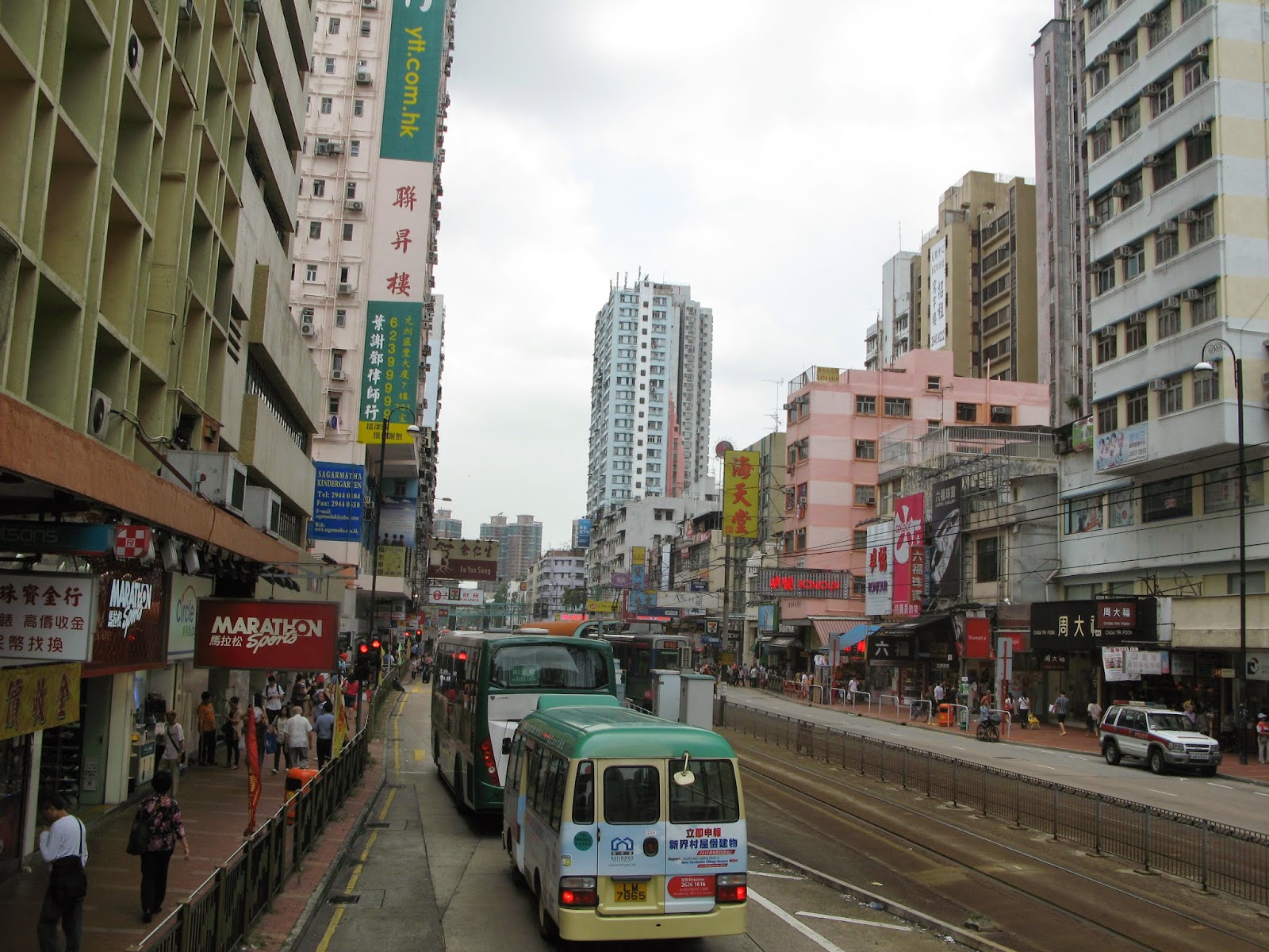
Officially speaking the start stop for this route is actually on the south bound side of Canton Road - around where the old Marine Police HQ (now known as 1881 Heritage - although I feel it should be called "Heritage" with double quotes) mall area starts. However, I usually catch this from the very first stop on the northbound side of Nathan Road next to The Peninsula Hotel (see below).

The wait for the bus is usually <10mins. I haven't checked the price recently but it was less than $10 when I first wrote this post...erm...4 years ago! Kids pay half afre, as usual, and under 4's get to ride for free. Here�s a few of the sites you will get to see as you whiz past at the usual HK bus speed (I believe William Shatner used to call it Warp Factor 10) such as the 100 year old banyan�s for starters (minus some that have been chopped down due to instability). Other than the trees there is the odd notable sight of the HQ for the Antiquities and Monuments office - a red brick building that was once the Kowloon British School - and St Andrew's Church. The latter is currently having its antique front wall being replaced by an ill-advised glass see through panel.


Just past the trees we come to the junction with Austin Road. The bus carries on up Nathan Road passing (on the left) the famous Shamrock Hotel - one of Kowloon's original high rise hotels built in 1952. Almost immediately opposite the hotel is the Prudential Hotel/Mall which occupies the site of what was once the childhood home of Bruce Lee. If you want to know more about that you can read this post, but we will carry on heading north along Nathan Road.


Shamrock Hotel left, Prudential Mall/Hotel right

Nathan Road looks fairly similar except when we get to the junction with the Gascoigne Road flyover. See the next snap. In case you are wondering the small sigh with the black circle is an 'accident black spot' sign. Nathan Road, it appears, is the most accident prone in the territory and has 12 other similar designated �black spots�. Apparently the Govt will give a place a "Black Spot" designation - complete with its own signpost - if there are six or more pedestrian accidents in a year, nine or more injury-causing accidents in a year or two or more fatal accidents in five years.
Not that the sign will achieve anything other than distract drivers wondering what it might mean therefore causing more accidents...

WATCH OUT!! Black Spot
At the junction with Waterloo Road the bus turns right on to said road and up towards the outskirts of Ho Man Tin. The action slows down a bit on Waterloo Road, but you can still see the very strangely shaped (and strangely named) Truth Lutheran Church as well as the famous Kowloon Wah Yan College and Kwong Wah Hospital. If you've read Martin Booth�s memoir Gwei Lo (US name: Goldenboy) should recognise the name of this road because it�s where the Four Seas Hotel used to stand. The building standing on that site now is the Kowloon Metropark Hotel. This happens to be the origin of the SARS virus in HK - brought there by a Mainland Chinese doctor and then spread around the globe from here in 2003. Not surprisingly the hotel group changed its name from Metropole to Metropark soon afterwards in an attempt to deflect some of the bad publicity.

Waterloo Road

Kowloon Metropark Hotel
At the end of Waterloo Road is the art deco Kowloon offices of C.L.P (China Light and Power). C.L.P is owned by the same family who own The Peninsula Hotel (amongst others), The Kadoories, am Iraqi Jewish family with links to HK and Shanghai stretching back many years. When I first posted this article several years ago I made a throwaway comment about a massive uproar ensuing if the building should ever be knocked down. It seems that it was a prophetic remark because demolition work started on the newer west wing of the building a couple of years ago. Thankfully the wing with the clock tower, as seen below, is set to stay.


C.L.P is actually the monopoly electricity supplier for Kowloon and the NT (Li Ka Shing owns the monopoly that supplies HK Island � HK Electric). The Kadoorie name can also be found on Kadoorie Avenue � the road where Leslie Cheung used to live (and where Andy Lau still does) and where one of HK�s more famous boys schools is situated: Diocesan Boy�s School as well as the famous experimental farm located in Lam Tsuen, Tai Po.
Notice the big red and yellow cube in the centre left of the upper picture? That's the emblem for the district we are about to enter - Kowloon City District. We've just been in and now left Yau Tsim Mong District (which as the name suggests, includes Yau Ma Tei, Tsim Sha Tsui and Mongkok).
Look to the left and right to see some older low rise mansion blocks dotted along the road. They are a good example of the type of houses that were here until building technology improved and taller buildings became the norm. It's a big shame because I much prefer these older buildings. They have so much more character.


One small part of Kowloon City district is the small area we are about to enter - Kowloon Tong. The area is well known for a variety of reasons but largely courtesy of the Kowloon Tong Garden Estate that was founded in the 1920's. Strictly speaking we are in fact now in the New Territories - a shocking revelation to many, I suspect, but the fact is that the New Territories lease signed in 1898 and enforced the following year included all the land between Boundary Street (which we are about to cross) up to the current border line with Mainland China. It's true...before 1899 the area immediately north of Boundary Street was still part of Mainland China!
Before we cross into the New Territories on the other side of Boundary Street though, pay attention to the rather elegant building on the left side of the road. This is St Theresa's Church, a local Catholic church that appears to have been partially funded with donations from a certain Benito Mussolini (apparently, there is a commemorative stone or plaque inside that bears his name).

On the opposite side of the road to the church is a (locally) famous school, the Maryknoll Convent School. Until recently the school grounds had a famous and rather old Norfolk Island pine tree. The bosses at the school seemed to be desperate to get rid of it, for whatever reason, but were restricted by a Government Preservation order (the school is a gazetted monument and any alterations to the grounds or building would require permission). So what happened? They (the school board) sneakily had the roots severed during some �drain maintenance�. The tree became unstable, was deemed a danger and was promptly cut down to the outrage of local residents and school alumni. What a bunch of sneaky bastards is all I can say...

Anyway, despite the sneaky people who run the school, you can see it�s a great looking building and dates back to around the same time as the founding of the aforementioned Garden Estate.
Speaking of the estate, as we approach it on the left in the bus, it's had its fair share of famous residents over the years including Bruce Lee, Lydia Shum, Chow Yun Fat, Stephen Chiao. Until a few years ago, Jackie Chan also had his main office at number 145 Waterloo Road. However, something happened that coincided with him sacking a bunch of peeps and going off about various political views that many HK'ers took him to task for and he upped and moved everything to a new HQ in Beijing. The plot that used to house his office has been completely levelled and nothing is left as you can see by the brief, blurry glimpse below.

Empty plot of 145 Waterloo Road
This was the famous location of one of JC's mad Japanese fans killing herself by ingesting poison after breaking into the property and for a time I figured he had it knocked down to stop people from trophy hunting etc. However, it turns out that the building was structurally unsafe - it was built to Jackie's very own design...! - and had to come down before it toppled like a house of cards. I did get some pictures before it went but I'll save those for another post.
Moving over to the opposite side of the road is what is now known as Kowloon East Barracks. Pre-1997 this place was known as Osborn Barracks, one of the larger accommodation centres for the British garrison's married members. The barracks were named after the Canadian soldier, John Robert Osborn, who saved his fellow soldiers from a Japanese grenade by throwing himself on top of it during the Battle for HK in December 1941. He was awarded a posthumous Victoria Cross. There is a statue dedicated to him in Hong Kong Park that many tourists mistakenly believe is an image of him, but in fact it actually depicts a WW1 soldier and was donated by the famous Eu family from their estate at Eucliffe (a long gone castle-like property in Repulse Bay). Before the statue was moved to the park, it was sited at these barracks.

The barracks are now the property of the PLA but to be honest there never seems to be much going on there, it's almost as though it's empty. Even in my 3 years in Kowloon I have only ever seen two perimeter patrols by PLA soldiers. Other than that it's as quiet as a mouse. This place is prime real estate and there have been talks about getting the land back from the military for real estate development, but the way this HK Govt is so scared of doing anything that shows initiative in the face of their Communist overlords, I don't think it will happen anytime soon.
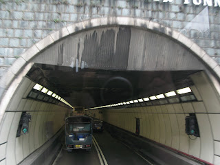
Anyway, moving on we head up past the Baptist Hospital and University before heading into Lion Rock Second Tunnel. From this angle Lion Rock doesn�t really look much like a lion anymore, you have to be much further east for that visual effect, but it�s still an impressive sight to behold. During the Occupy Central protests last year (2014), various yellow-coloured banners proclaiming "I want Universal Suffrage" were installed on the rock, much to the annoyance of the authorities. Sadly, I was never quick enough to grab a snap of any of the banners, but you can see one here.

Lion Rock
Further along the road it starts to slope up and this is where we are on the lower slopes of the Kowloon mountains with Lion Rock ahead and beacon Hill to the left. Nearby is Beacon Hill Road and the scene of Bruce Lee's death in Betty Ting Pei's apartment in 1973 and on the right we pass the apartment blocks that sit on Broadcast Drive. Once the home of various broadcasters including TVB, ATV (RTV/Rediffusion) and RTHK, only RTHK has managed to stick around and the sites of the other two companies have since been redeveloped into luxury housing. The snap below shows Peninsula Heights that stands on the former TVB studio lot at #63 Broadcast Drive.

It's not long before we are heading into Lion Rock Tunnel itself. The northbound tunnel we are entering is the original tunnel opened in 1967. At the time it was a dual direction tunnel with two lanes - one northbound and the other southbound. However, the inevitable rise of the machines meant that a second tunnel was dug out and opened in the late 70's the cater for the increase in traffic so now the original tunnel is northbound only and the new tunnel handles the traffic coming south into Kowloon.

Lion Rock Tunnel 1
Once on the other side of the tunnel we are in what most people now consider to be the real New Territories - even though, as mentioned, we've strictly been in them since crossing Boundary St.
After passing the toll booths you can look up to your right and see the famous Amah rock (Mong Fu Sek in Cantonese which means �staring after husband rock�). The legend is part of local folklore and is quoted in all the tour books � even my kids learned about it in kindergarten. It's well worth a trip up there if you get the chance (and reasonably easy to get to) but even from the bus you get a good glimpse. Sadly, I was a bit slow on the shutter and missed the opportunity for a better shot, this one will have to do.

Past here its a slow descent into Shatin valley, not much to see until we cross the �river� (the body of water formerly known as Shatin Sea) and you can see a building I mentioned previously in my Shatin -> Tai Po walk post. Yes, it�s the 'pretending-to-but-not-really-floating' floating restaurant.

We�re now on the home straight (for 6 years it literally was for me because I lived in Tai Po) and we join the Tolo Highway as it motors past the Shatin racecourse (I won HK$1800 there once � sheer fluke though I have to add) and further on down past the Chinese University of HK which sits on the hillside on the western side of the valley. (incidentally the remaining shots are all from Streetview because my trusty camera ran out of power *sigh*).

Racecourse on the right

University (CUHK) on the left
You can just see some of the University buildings peeking out from the hilltop above. Can you see the rather large-bore pipe that is running along the side of the highway? I believe this is the pipe that carries water taken from Plover Cove reservoir down towards Kowloon (I did see a schematic once but can�t remember where the water ends up before it gets put into the mains system?).
You�ll also notice a rather swish looking development just past it called Deerhill Bay. It sits on the former site of St Christopher�s Home � an orphanage run by the Anglican Church. The site was sold to Li Ka Shing (surprise surprise) with certain conditions in place so that he could build the Deerhill complex. The church got a massive payoff and several of the units as part of the deal and got into a spot of bother with the Inland Revenue as a result.

Deerhill Bay up on the hill
Incidentally, there is a relic from the KCRC�s past just below the Deerhill development. The old track route used to take the train along the bottom of the slope that the development sits on. I�ve marked it on the shot below but there is a distinct pathway in the land where the track used to sit before it started taking the more direct route alongside where the highway now runs.

Old route of the KCR track
Anyway, soon the bus moves into the left hand slip lane and takes the exit for Tai Po Market. Tai Po Market is the older part of town and Kwong Fuk Road is its main thoroughfare. Prior to the development of Tai Po into a 'New Town', the section of this road between Yuen Chau Tsai and Tai Po Market proper was a floating (and stilted) village of Hoklo boat people. It was the presence of these boat people that led to the establishment of the Tai Wong Yeh temple on Yuen Chau Tsai (see below). If you want to see some excellent pictures documenting the floating village then the Nick Dewolf archive on FLICKR is worthy of a look.

Tai Wong Yeh Temple in Tai Po Market
Of course the causeway is no more and the land has been filled in and a large proportion of the families were rehoused in Kwong Fuk Estate � the nearby Govt housing estate. Kwong Fuk Estate is actually the next stop on the route since leaving Kowloon � one of the reasons this bus gets to Tai Po quite quickly is the lack of stops between Lion Rock Tunnel and here. You could get off here if you wanted to (and you can catch the same bus back into Nathan Road from the stops on the opposite side of the road � you see, easy) or you can stay on for another stop and get off in the middle of Kwong Fuk Road.
If you do the latter you will find yourself going down the oldest and most important road in Tai Po. The trees on the left conceal the Old District Office (North) as well as the old Tai Po Police Station (currently being turned into a holiday camp I think?) and on the right, hidden away, is the old Police Bungalow � now the Norwegian International School.
If you do the latter you will find yourself going down the oldest and most important road in Tai Po. The trees on the left conceal the Old District Office (North) as well as the old Tai Po Police Station (currently being turned into a holiday camp I think?) and on the right, hidden away, is the old Police Bungalow � now the Norwegian International School.

Kwong Fuk Road
The area it's built on, Tung Cheong Street, used to be a harbour front fish market where all the local fisherman would bring their daily catch to sell to the local population. This is one of the reasons why a large fishing community managed to spring up just down the road. I don�t know when the market disappeared but it was probably around the time of the reclamation works in the 70�s.

Man Sze Cheung Yuen