Hongkong A Walking Tour of Tai Po History
I was a at a bit of a loose end the other day so I figured I would head back to my old stomping ground in Tai Po and put together a small walking tour that takes in most of the interesting sites around town. It's not a definitive list because Tai Po District itself is massive and encompasses much of the surrounding area including Lam Tsuen, Plover Cove, the whole of the Tolo Channel including the northern coastline of Sai Kung and various outlying islands such as Tap Mun and even Tung Ping Chau (yes, ALL are part of Tai Po District). Anyway, this is a short tour that takes you around much of the town and takes you past a little bit of history, some stuff I personally find curious and, I guess, some nice views (at least weather and pollution permitting).

I've also knocked up a Google Map that you can printout and follow. Sadly, it looks as though Google have put some sort of block inside Google Maps to prevent a screen shot from being taken (at least my snipping tool doesn't work on it anymore) so you can click on the link below to get the route: https://www.google.com/maps/d/edit?mid=zo9nKhf9lDbE.kx_4WMK-dDd4&usp=sharing
I've planned the walk with the assumption that people will want to start and end at the Tai Po Market MTR station, however, the route passes various bus stops along the way so there is no reason to follow it all through if you fancy hopping on the bus and heading out rather than traipsing back to the station. The walk is around 5.5 km and if just walked without stops would take about an hour. Given that you may want to stop for food/drinks as well as wander around the (free) museum then you can easily stretch this out to a full morning or afternoon.
Anyway, here is a list of stuff that you will see on the walking tour, some of it already on the Tai Po tourist itinerary, some of it not:

Once on the other side of the track you arrive at a rather quiet and very pleasant garden area called Wan Tau Kok Playground. It's an odd name for such a pretty place because it is nicely landscaped and is home to a variety of extremely large mature trees.


The playground part of the name refers to the upper level that houses tennis courts, and 5-a-side football pitch and the local Leisure and Cultural Services (LCSD) management office and public toilets. The garden area where you now are has a small pavilion and some benches and is popular with the older folk who come here to practise their Tai Chi in the open space and also various Indonesian helpers who congregate here on a Sunday to sing and dance and generally socialise with each other.
By far the standout feature of the garden though is the Pai Lau (ornamental archway) commemorating the nearby Tai Po Government Primary School.


The school was actually the first Government funded primary school to open up in the area, way back in 1953. It's an important milestone because prior to the school being opened most children were educated within their villages and many didn't even have that option. I'm not sure how much of this modern park area was encompassed within the school grounds (if at all) but the school itself still takes pride of place on a hillock above the garden. It's no longer used as a school and is currently standing empty after being used, for several years, by the local National Education Centre.
This latter group is the pro-Communist China organisation that wishes to see 'national and moral education' as part of the local school curriculum. Its proposed introduction to schools several years back caused large demonstrations and an eventual climb down by the Govt, who finally realised they were onto a loser. The centre closed down soon after when various objections were raised to the potential renewal of the lease.

Anyway, moving on the other side of the park and we come to Wan Tau Kok Lane. Downhill is the old Government Clinic at #20 Wan Tau Kok Lane that has been taken over by the LCSD as their conservation office. There's a small path that circles the building, so feel free to wander around. It's quite a nice building and recently had a new roof put on it - when the scaffolding first went up I started to get worried they were preparing for its demolition... thankfully, they weren't.


Notice the small hut at the far end of the car park? That was the original ambulance garage for the clinic. The reason it looks a bit small/low is because we are talking about hand pulled ambulances here, I guess you have to imagine a flatbed version of a rickshaw. It's nice to see such an old building being reused and highlights the fact that when the Govt already has ownership of a property keeping it is easy, it's when private property comes into play that things get tricky.
We join Wan Tau Kok Lane again at the side of the clinic and walk up hill. It's a fairly steep climb because this is indeed a hill and one with a fair amount of history surrounding it (well, on top of it as well in the literal sense). At the top of the hill are two more antiquated colonial structures: the old Police Station and the old District Office (North).
We've seen the old Police Station on this blog previously when I managed to (legally) get inside the compound prior to its renovation for adaptive reuse. Now it has been well and truly taken over by the Kadoorie Farm Botanical and Garden.


For a while in the 1990's the Marine Police took over the complex while they were waiting for their new Shatin marine base to be built. However, its original purpose of course was as the local Police base. The hill we are on was once known as Flagstaff Hill and was the location for the official flag raising ceremony when the British Colonial Govt took over the New Territories in 1899. There was large scale opposition to the leasing of the NT to the British and a large local army - formed from many village militias in Hong Kong and over the (new) border in Shenzhen - who put up armed resistance. After a 6 day running battle and 500 militia deaths, the villagers surrendered to the inevitable once they realised that the Brits weren't there change their way of life and the uprising leaders were given key positions in the local administration for liaison with the Govt. You can read more about it here.
Further up the hill is the old District Office (North), now used as a Scout administration centre. When this building it was first opened in 1907 it was the main Govt administration centre for the whole of the New Territories. It was placed in Tai Po because then, as now, Tai Po is about equidistant from both the border with Mainland China and the centre of the former Colonial administration on Hong Kong island (then Victoria City, now Central). It also served - up until the 1960s - as the local magistrate court. The red brick and colonnaded verandas still make it a popular location for film crews and off the top of my head I know the recent Donnie Yen film Iceman (2014) had scenes filmed there as well as 2006's Isabella.


You can't go into the building unfortunately, but the current tenants don't seem to have any problem with you having a good wander around the periphery. In fact, this is one of the popular places in Tai Po for newly weds to get their pre-wedding photos done so don't be surprised if you come here and find a couple dressed up to the neck in the most ridiculous wedding attire available (blokes have a tendency to wear very cheesy white tuxedos and the women tend to look like over iced wedding cakes). Anyway, heading back down to the police station you need to take the path on the right that takes us down to Kwong Fuk Road. This is actually the original public path up to the office, it forms a dog leg down the hill but if you fancy some quiet time walk up to the small - but usually deserted - rest garden reached by taking the uphill path where the main path turns.

Once down onto Kwong Fuk Road you can see some of the buildings on the opposite side of the road. There are two main ones of interest, although one of them is difficult to see unless you cross the road and walk uphill. It's the Tai Po Bungalow, a former Govt residence originally used by senior officers staffing the old Police Station across the road, but now used by the Norwegian International School Kindergarten. Next to it is the Groom's Cottage. Most likely this was the home of whoever looked after the police horses? Originally it was part of the same complex of buildings but the latter has since been taken over by the Agricultural, Fisheries and Conservation Dept (AFCD). I have no idea what it is used for though and rarely see anyone coming in or out.


A similar thing can be said about the interesting building next door called Man Sze Cheung Yuen. All I can gather is that it was built in 1955 and was originally owned by a Mr Tang York Fan from nearby Tai Po Tau (the local Tang Clan stronghold - we'll get to that later). It once had a rather nice mature orchard in the extensive back garden but that has recently been completely cut down and cleared in preparation for something - perhaps the land at the back of the house has been sold to a developer? It looks as though Mr Tang's son, Tang Pui-tat - a former local district councillor and also race horse owner - is probably the current owner. But whether anyone actually lives there is unclear.

Next door is an interesting, similar era (actually,slightly older) tenement building consisting of three blocks. Just recently the scaffolding went up and it looked like they might be knocked down but thankfully the owner has decided to give them a bit of a spruce up and the result can be seen below. It's nice to see when an old building like this can be given a bit of a face lift (and an internal remodelling in this case) to make some fairly attractive and large living spaces. It's a trend that needs to continue in all areas of HK. It's also nice to see that the old-style road sign on the building (just visible in the picture) has been kept.

Our next stop is Tai Ming Lane square, so we need to continue walking down Kwong Fuk Road (crossing Wan Tau Lane and Wan Tau Street) until just past the pedestrian crossing. The entrance to the square is marked by some (now faded) ornate red posts. Turn left along Kwong Fuk Lane and enter the square.
The centre piece of the square is a small childrens' playground and fountain but surrounding it all is lots of local shops and stores. One of the favourite places here for visiting tourists is the Yat Lok BBQ restaurant, made famous by Antoine Bourdain a few years ago. These days it seems to have rather erratic opening hours but well worth stopping off if you have the chance and ordering some of its signature dishes - either the roast goose or Cha Siu pork. The owners speak good English so no need to be shy.

Crossing the square to the opposite side we will take the opposite exit along Tai Kwong Lane which pops us out by a pedestrian crossing. Directly opposite is the Tai Po Complex - it's basically the main building for the local Govt services including the local wet market, cooked food centre, council administration, sports centre and a rather excellent public library. Feel free to head up to level for lunch or a drink but when you've finished we turn left after the crossing and walk around the front of the building along Wan Tau Street towards the railway bridge. Just here on the left is a bus stop where you can catch routes such as the 64K (which takes you into Yuen Long via Lam Tsuen and Kadoorie Farm) or the 28K green minibus (which will take you along the scenic Tai Po Road down into Shatin). However, we are walking under the rail bridge and then taking an immediate right hand turn towards Pan Chung village.
Pan Chung is a long-established village inhabited largely by members of the Mak clan. It's actually a walled village and the only one in Tai Po that I know of. There are several classifications of walled village in Hong Kong and this one falls into the category that doesn't have exterior walls per se, but the village does have a central gatehouse and the periphery is formed largely of peoples' homes.

Directly opposite the gate house of Pan Chung village is the old pedestrian underpass for the railway. It's as old as the rail track (so >100 years) but has seen a little bit of modification in that time.


In fact you can see the extent of the original tunnel in the lower picture - it's the arched portion. The angular section of the roof shows where the underpass had to be extended when the track was doubled during modernisation works in the late 1970's.
Once out of the tunnel, turn left and walk towards Po Heung Street. Right in front of you now is where the new Po Heung estate is being built. This are once held the wet market prior to the construction of the new Tai Po Complex. It was common to walk through here and have to step over the rivers of blood running into the central gutter from the various live (soon to be dead) poultry vendors. Once the complex was complete the wet market moved indoors and bird flu pretty much put paid to the live poultry business. Even now, every time a bird flu case pops up, the Govt embarks on a massive bird cull and the poultry vendors bear the brunt.
Walk down Po Heung Street on the far side of the road and take the next left. It's Wai Yi Street - a very typical local street filled with local shops. There's an older building here amongst the higher ones that seems to date back to around 1960. This style of building was essentially the next generation of buildings in the Tai Po Market area - three-storey walk ups that replaced the older two story shop houses. There's not that much of either left around these days.

At the end of Wai Yi Street is On Fu Road, the original access road for the Tai Po Market railway station. On Fu Road was basically built so traffic from the nearby Tai Po Road (later renamed Kwong Fuk Road in this area) could access the railway. This intersection/junction is actually one of the oldest parts of town because it marks the southern end of the market that gives its name to the area. The market was set up by an alliance of villages (called the Alliance of 7) in direct competition to a Tang-dominated market on the other side of the local river.
This new market set up in 1892 and based on Fu Shin Street (directly ahead) was funded by generous donations from villagers within the 'alliance'. The funding provided for not only the market but also a new well, a temple that was to serve as the market administration centre and a bridge allowing people to avoid paying a river crossing levy to the Tang's who also controlled the river ferry. Confusingly this new market was originally called Tai Wo market. It was such a success that the old market went out of business and the Tang's influence in Tai Po was drastically reduced. The aforementioned market well is still around and is enclosed within a small wall, sharing the space with a local deity shrine - probably the well god, but I'm not sure.


Sadly, it appears that the historical significance of the well is lost on the people that run the adjacent market stall because they are using the space to dump their cardboard packing boxes. Never mind.

Immediately opposite is the top end of Fu Shin Street and you have the choice of heading down here (it's nothing special these days to be honest, just a bog-standard street market), or turning left and walking uphill towards the Railway Museum. Just before you get to the museum entrance you can see the Tai Po Rural Committee building on your left. This is actually the new site for this office. Their old building on Po Heung Street, next to the old wet market site, was sold and demolished to make way for the aforementioned Po Heung estate. In short, the rural affairs committee is the body responsible for the villagers in the area.

Next up is the Railway Museum. It's long been one of my favourite museums in Hong Kong and my kids love it. Based out of the original Tai Po Market train station (built in 1913) it has various displays showing the evolution of the line from its earliest days up to the present, as well as old rolling stock that can be boarded. It's well worth spending some time in (anything between 30 mins to and hour is usually more than enough).


If you do opt to go in you will be sharing space (if not time) with such luminaries as Robert Culp and Bill Cosby (okay, I guess the latter isn't so much of a luminary these days) who filmed an episode of their hit series I Spy here in the mid-60's (see below).

Moving on from the museum, head down Yan Hing Street. On the way to the bottom there are a couple of side roads. The first one, Yan Wo lane, houses the North Sai Kung Rural Committee building. Seems an odd place to put an office for a Sai Kung committee but, if you recall from the introduction, a large swathe north of Sai Kung actually lies in Tai Po District - hence why there is a committee building in Tai Po Market. On an aside, from a historical point of view, the Tai Po Market was patronised by villagers from all over the area including those from the island of Tap Mun and certainly by villagers who lived in northern Sai Kung - the reason being that Tai Po was easier to reach by boat than Sai Kung was on foot.

The next road down is Hei Yuen Street. Hei Yuen is the Cantonese term for a cinema and there was once the large Tai Po Theatre on this street. The cinema has long since gone, closing in the late 50's, but I have heard from people who remember it saying that it had an open well in the foyer! The site where it stood now hosts a block of flats called Moon House and, interestingly, right next door to Moon House is the administrative HQ of the aforementioned Alliance of Seven - the village alliance responsible for the Fu Shin Street market.
Moving further down the road you will see the man Mo Temple of the opposite side of the road. This is the rear part of the building but there are alleys either side of it that allow you access to Fu Shin Street and the main entrance. The building is a gazetted monument and has a brass plaque inside outlining some of its history.


If you've had enough of the temple then you can head to the end of Fu Shin Street (or Yan Hing Street if you didn't bother walking to the front of the temple) and turn right. Our next stop is the Kwong Fuk bridge, a name with some history even if the current incarnation of it isn't that old. However, before we get there take a quick look to the right and you may be able to spot this wall. Look closely and you should be able to discern the faint outline of an old Winston cigarette advert.

Long before modern printing technology allowed the creation of massive plastic advertising posters, in Hong Kong many adverts were simply painted onto the side of the wall. It's a practice that no longer happens but remnants can still be found around town if you look (not far from here is also the faded remainder of a huge San Miguel beer advert). Anyway, moving on and over to the bridge. The modern version is rather ornate and makes a fine addition to the general area with its green roof and bright red columns, but its former namesake was a vehicular bridge that allowed the Tai Po Road to continue on towards Fanling. The remnants of the previous bridge can be found on the way to the current one - they are the large granite blocks and balustrades that line the pathway. The end block (see below) bearing the bridge's inscribed name in English and Chinese and the date of its construction - 1957.

Once over the bridge we need to cross and walk up Ting Kok Road. Before the reclamation this road marked the waterfront to the harbour. Tai Po's conversion into a 'New Town' in the late 70's and early 80's saw large amounts of the harbour reclaimed to facilitate building works for what is now Tai Po Centre and (further north) the Tai Po Industrial Estate. On the way towards Mei Sun Lane you can see there's an old art-deco style shop on the side of the road. The buildings dept has a 1945 build date for this property which probably means it's actually pre-war.


Considering its age it's in fairly good condition and it is most certainly the oldest building along this row of shops and residential properties. Even the temple further along, Sing Kung Cho Tong, is a rebuild of an earlier building. The original building was built by a Hong Kong businessman in 1936 to worship Master Guang Shing Chi (I don't know who he is but assume he was a traditional Chinese medicine practitioner?) and to offer medicine and medical advice to the general public. The current building is a replica of the original building in Guangzhou. Despite being a place built for meditation, it was unfortunately taken over by the occupying Japanese forces during the Second World War and used as a military base. As a result many of the local Tai Po residents and members of the anti-Japanese militia (East River Brigade) were taken there and tortured/persecuted.


Strolling around the inside you will find it is covered with all kinds of medicinal plants and bonsai, and in fact is very peaceful considering its location on one of the busiest roads in Tai Po (just down the road are the main Govt offices and Fire Station). On my first trip here the place was deserted and I had a free run of the place with my camera, however, on a subsequent trip I was approached by the custodian, a genial grey-haired lady who sternly told me I couldn�t take photos (I had my camera in my hand) but when convinced of my honest intentions was quite happy to tell me a bit of the history of the place. The medicinal dispensary that is associated with the temple is located next door.

Take the next left turn into Mei Sun Lane and the first right is a street called Kau Hui Chik Street. The name literally translates as Old Market Street and it is thought this street was the original home of the previously discussed old market that was controlled by the Tang clan before losing out to the new Tai Wo market over the river. Unfortunately, this little tidbit of information can't be confirmed either way but given how HK often has its history written into the signs and layouts of the streets then it is quite possible. These days it seems to be the place to go to if you fancy some Korean food.


I've also knocked up a Google Map that you can printout and follow. Sadly, it looks as though Google have put some sort of block inside Google Maps to prevent a screen shot from being taken (at least my snipping tool doesn't work on it anymore) so you can click on the link below to get the route: https://www.google.com/maps/d/edit?mid=zo9nKhf9lDbE.kx_4WMK-dDd4&usp=sharing
I've planned the walk with the assumption that people will want to start and end at the Tai Po Market MTR station, however, the route passes various bus stops along the way so there is no reason to follow it all through if you fancy hopping on the bus and heading out rather than traipsing back to the station. The walk is around 5.5 km and if just walked without stops would take about an hour. Given that you may want to stop for food/drinks as well as wander around the (free) museum then you can easily stretch this out to a full morning or afternoon.
Anyway, here is a list of stuff that you will see on the walking tour, some of it already on the Tai Po tourist itinerary, some of it not:
- Tai Po Govt Primary School Pai Lau and Wan Tau Kok garden
- Old Govt clinic (now an LCSD office)
- Old District Office North
- Old Tai Po Police Station
- Man Sze Chung Yuen
- Groom's Cottage and Tai Po Bungalow
- Four lane square
- Tai Po complex
- Pan Chung village
- Old market well
- Fu Shin Street
- Hong Kong Railway Museum
- Man Mo Temple
- Kwong Fuk Bridge
- Art deco building along Ting Kok Road
- Sing Kung Cho Tong
- Old Market Street
- Tin Hau Temple
- Yuen Chau Tsai/Island House
- Tai Wong Yeh Shrine
Once on the other side of the track you arrive at a rather quiet and very pleasant garden area called Wan Tau Kok Playground. It's an odd name for such a pretty place because it is nicely landscaped and is home to a variety of extremely large mature trees.


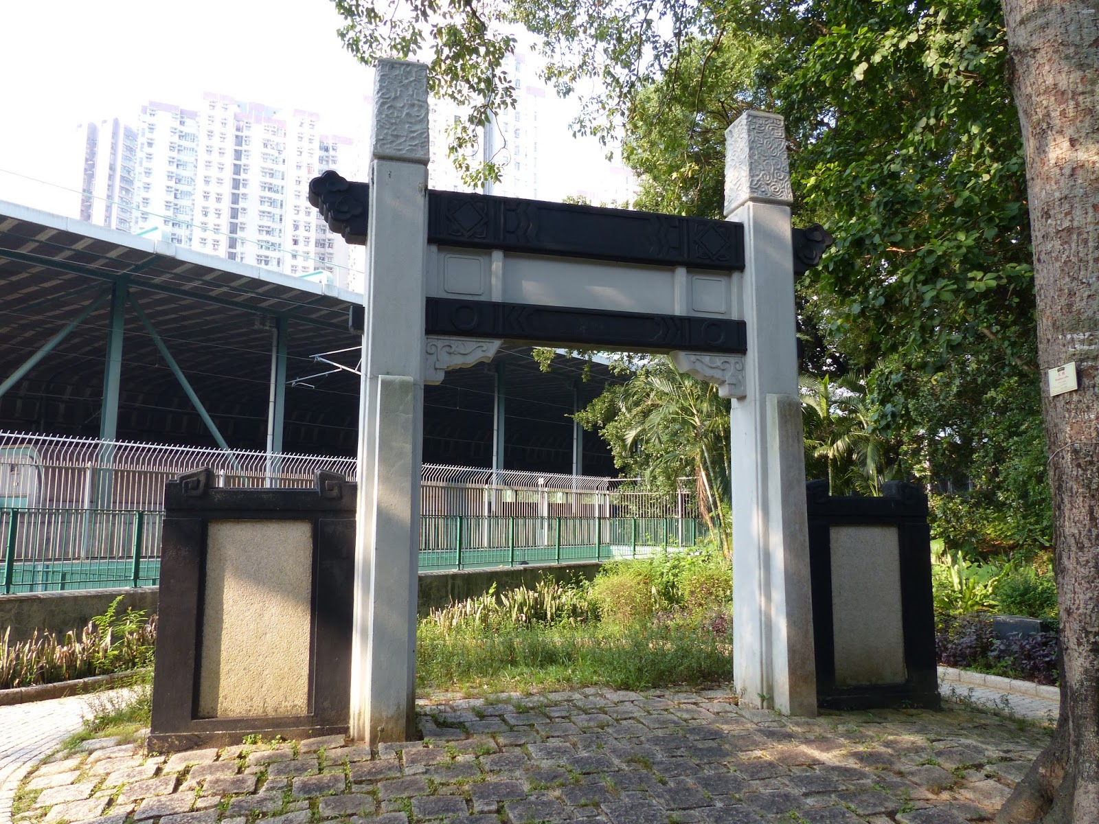
Wan Tau Kok Playground - the park/garden section
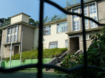
By far the standout feature of the garden though is the Pai Lau (ornamental archway) commemorating the nearby Tai Po Government Primary School.

The school was actually the first Government funded primary school to open up in the area, way back in 1953. It's an important milestone because prior to the school being opened most children were educated within their villages and many didn't even have that option. I'm not sure how much of this modern park area was encompassed within the school grounds (if at all) but the school itself still takes pride of place on a hillock above the garden. It's no longer used as a school and is currently standing empty after being used, for several years, by the local National Education Centre.
This latter group is the pro-Communist China organisation that wishes to see 'national and moral education' as part of the local school curriculum. Its proposed introduction to schools several years back caused large demonstrations and an eventual climb down by the Govt, who finally realised they were onto a loser. The centre closed down soon after when various objections were raised to the potential renewal of the lease.


Former Tai Po Govt Primary School
Anyway, moving on the other side of the park and we come to Wan Tau Kok Lane. Downhill is the old Government Clinic at #20 Wan Tau Kok Lane that has been taken over by the LCSD as their conservation office. There's a small path that circles the building, so feel free to wander around. It's quite a nice building and recently had a new roof put on it - when the scaffolding first went up I started to get worried they were preparing for its demolition... thankfully, they weren't.

Path around the old clinic


Rear and side views of the old clinic building

Notice the small hut at the far end of the car park? That was the original ambulance garage for the clinic. The reason it looks a bit small/low is because we are talking about hand pulled ambulances here, I guess you have to imagine a flatbed version of a rickshaw. It's nice to see such an old building being reused and highlights the fact that when the Govt already has ownership of a property keeping it is easy, it's when private property comes into play that things get tricky.
We join Wan Tau Kok Lane again at the side of the clinic and walk up hill. It's a fairly steep climb because this is indeed a hill and one with a fair amount of history surrounding it (well, on top of it as well in the literal sense). At the top of the hill are two more antiquated colonial structures: the old Police Station and the old District Office (North).
We've seen the old Police Station on this blog previously when I managed to (legally) get inside the compound prior to its renovation for adaptive reuse. Now it has been well and truly taken over by the Kadoorie Farm Botanical and Garden.


For a while in the 1990's the Marine Police took over the complex while they were waiting for their new Shatin marine base to be built. However, its original purpose of course was as the local Police base. The hill we are on was once known as Flagstaff Hill and was the location for the official flag raising ceremony when the British Colonial Govt took over the New Territories in 1899. There was large scale opposition to the leasing of the NT to the British and a large local army - formed from many village militias in Hong Kong and over the (new) border in Shenzhen - who put up armed resistance. After a 6 day running battle and 500 militia deaths, the villagers surrendered to the inevitable once they realised that the Brits weren't there change their way of life and the uprising leaders were given key positions in the local administration for liaison with the Govt. You can read more about it here.
Further up the hill is the old District Office (North), now used as a Scout administration centre. When this building it was first opened in 1907 it was the main Govt administration centre for the whole of the New Territories. It was placed in Tai Po because then, as now, Tai Po is about equidistant from both the border with Mainland China and the centre of the former Colonial administration on Hong Kong island (then Victoria City, now Central). It also served - up until the 1960s - as the local magistrate court. The red brick and colonnaded verandas still make it a popular location for film crews and off the top of my head I know the recent Donnie Yen film Iceman (2014) had scenes filmed there as well as 2006's Isabella.


You can't go into the building unfortunately, but the current tenants don't seem to have any problem with you having a good wander around the periphery. In fact, this is one of the popular places in Tai Po for newly weds to get their pre-wedding photos done so don't be surprised if you come here and find a couple dressed up to the neck in the most ridiculous wedding attire available (blokes have a tendency to wear very cheesy white tuxedos and the women tend to look like over iced wedding cakes). Anyway, heading back down to the police station you need to take the path on the right that takes us down to Kwong Fuk Road. This is actually the original public path up to the office, it forms a dog leg down the hill but if you fancy some quiet time walk up to the small - but usually deserted - rest garden reached by taking the uphill path where the main path turns.

Once down onto Kwong Fuk Road you can see some of the buildings on the opposite side of the road. There are two main ones of interest, although one of them is difficult to see unless you cross the road and walk uphill. It's the Tai Po Bungalow, a former Govt residence originally used by senior officers staffing the old Police Station across the road, but now used by the Norwegian International School Kindergarten. Next to it is the Groom's Cottage. Most likely this was the home of whoever looked after the police horses? Originally it was part of the same complex of buildings but the latter has since been taken over by the Agricultural, Fisheries and Conservation Dept (AFCD). I have no idea what it is used for though and rarely see anyone coming in or out.

Groom's Cottage

Tai Po Bungalow (now Norwegian International Kindergarten)
A similar thing can be said about the interesting building next door called Man Sze Cheung Yuen. All I can gather is that it was built in 1955 and was originally owned by a Mr Tang York Fan from nearby Tai Po Tau (the local Tang Clan stronghold - we'll get to that later). It once had a rather nice mature orchard in the extensive back garden but that has recently been completely cut down and cleared in preparation for something - perhaps the land at the back of the house has been sold to a developer? It looks as though Mr Tang's son, Tang Pui-tat - a former local district councillor and also race horse owner - is probably the current owner. But whether anyone actually lives there is unclear.

Man Sze Cheung Yuen
Next door is an interesting, similar era (actually,slightly older) tenement building consisting of three blocks. Just recently the scaffolding went up and it looked like they might be knocked down but thankfully the owner has decided to give them a bit of a spruce up and the result can be seen below. It's nice to see when an old building like this can be given a bit of a face lift (and an internal remodelling in this case) to make some fairly attractive and large living spaces. It's a trend that needs to continue in all areas of HK. It's also nice to see that the old-style road sign on the building (just visible in the picture) has been kept.

Our next stop is Tai Ming Lane square, so we need to continue walking down Kwong Fuk Road (crossing Wan Tau Lane and Wan Tau Street) until just past the pedestrian crossing. The entrance to the square is marked by some (now faded) ornate red posts. Turn left along Kwong Fuk Lane and enter the square.
The centre piece of the square is a small childrens' playground and fountain but surrounding it all is lots of local shops and stores. One of the favourite places here for visiting tourists is the Yat Lok BBQ restaurant, made famous by Antoine Bourdain a few years ago. These days it seems to have rather erratic opening hours but well worth stopping off if you have the chance and ordering some of its signature dishes - either the roast goose or Cha Siu pork. The owners speak good English so no need to be shy.

Tai Ming Lane Square
Crossing the square to the opposite side we will take the opposite exit along Tai Kwong Lane which pops us out by a pedestrian crossing. Directly opposite is the Tai Po Complex - it's basically the main building for the local Govt services including the local wet market, cooked food centre, council administration, sports centre and a rather excellent public library. Feel free to head up to level for lunch or a drink but when you've finished we turn left after the crossing and walk around the front of the building along Wan Tau Street towards the railway bridge. Just here on the left is a bus stop where you can catch routes such as the 64K (which takes you into Yuen Long via Lam Tsuen and Kadoorie Farm) or the 28K green minibus (which will take you along the scenic Tai Po Road down into Shatin). However, we are walking under the rail bridge and then taking an immediate right hand turn towards Pan Chung village.
Pan Chung is a long-established village inhabited largely by members of the Mak clan. It's actually a walled village and the only one in Tai Po that I know of. There are several classifications of walled village in Hong Kong and this one falls into the category that doesn't have exterior walls per se, but the village does have a central gatehouse and the periphery is formed largely of peoples' homes.

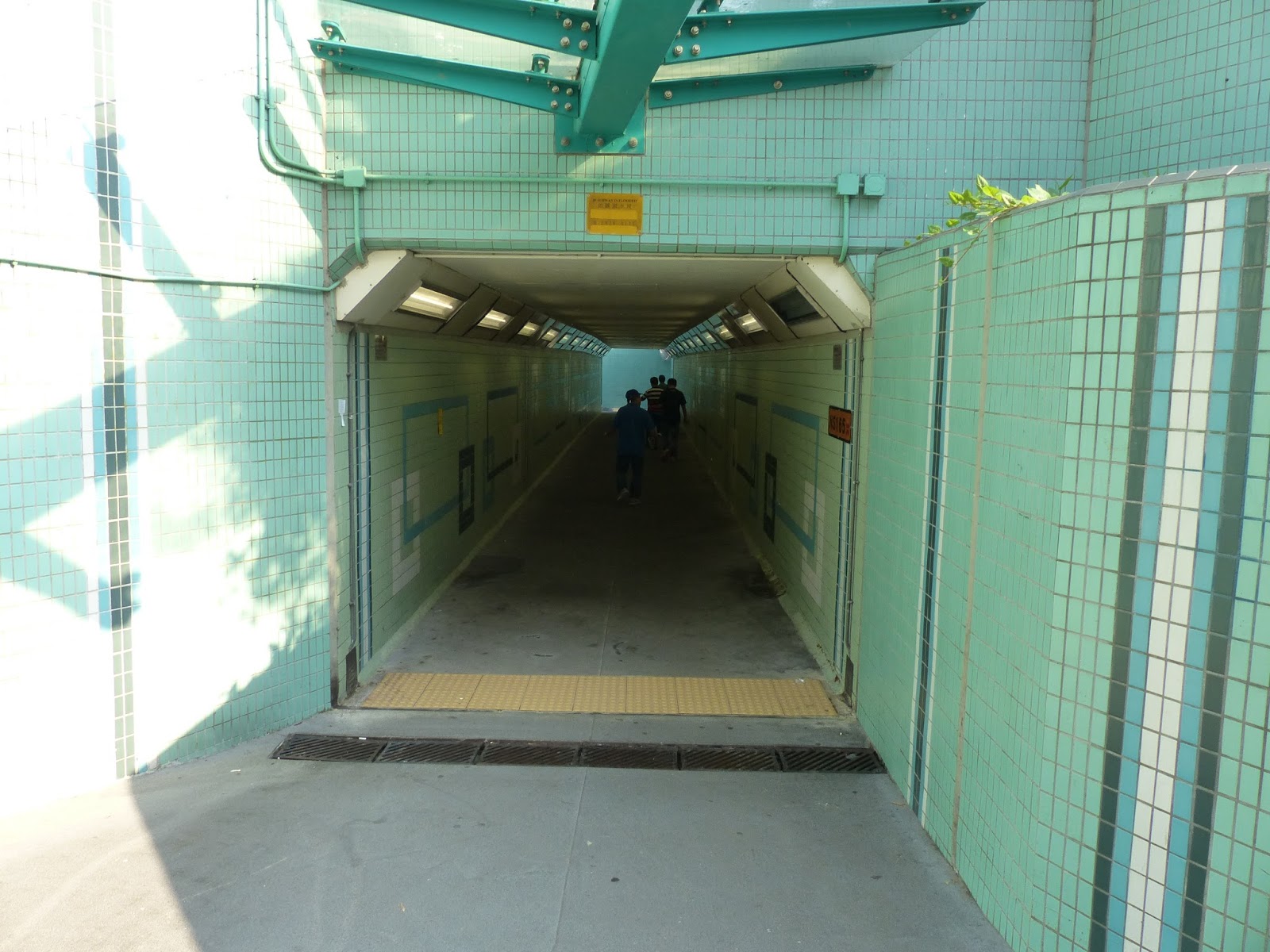
Directly opposite the gate house of Pan Chung village is the old pedestrian underpass for the railway. It's as old as the rail track (so >100 years) but has seen a little bit of modification in that time.

Front side

Rear view
In fact you can see the extent of the original tunnel in the lower picture - it's the arched portion. The angular section of the roof shows where the underpass had to be extended when the track was doubled during modernisation works in the late 1970's.
Once out of the tunnel, turn left and walk towards Po Heung Street. Right in front of you now is where the new Po Heung estate is being built. This are once held the wet market prior to the construction of the new Tai Po Complex. It was common to walk through here and have to step over the rivers of blood running into the central gutter from the various live (soon to be dead) poultry vendors. Once the complex was complete the wet market moved indoors and bird flu pretty much put paid to the live poultry business. Even now, every time a bird flu case pops up, the Govt embarks on a massive bird cull and the poultry vendors bear the brunt.
Walk down Po Heung Street on the far side of the road and take the next left. It's Wai Yi Street - a very typical local street filled with local shops. There's an older building here amongst the higher ones that seems to date back to around 1960. This style of building was essentially the next generation of buildings in the Tai Po Market area - three-storey walk ups that replaced the older two story shop houses. There's not that much of either left around these days.

At the end of Wai Yi Street is On Fu Road, the original access road for the Tai Po Market railway station. On Fu Road was basically built so traffic from the nearby Tai Po Road (later renamed Kwong Fuk Road in this area) could access the railway. This intersection/junction is actually one of the oldest parts of town because it marks the southern end of the market that gives its name to the area. The market was set up by an alliance of villages (called the Alliance of 7) in direct competition to a Tang-dominated market on the other side of the local river.
This new market set up in 1892 and based on Fu Shin Street (directly ahead) was funded by generous donations from villagers within the 'alliance'. The funding provided for not only the market but also a new well, a temple that was to serve as the market administration centre and a bridge allowing people to avoid paying a river crossing levy to the Tang's who also controlled the river ferry. Confusingly this new market was originally called Tai Wo market. It was such a success that the old market went out of business and the Tang's influence in Tai Po was drastically reduced. The aforementioned market well is still around and is enclosed within a small wall, sharing the space with a local deity shrine - probably the well god, but I'm not sure.


Sadly, it appears that the historical significance of the well is lost on the people that run the adjacent market stall because they are using the space to dump their cardboard packing boxes. Never mind.

Fu Shin Street market
Immediately opposite is the top end of Fu Shin Street and you have the choice of heading down here (it's nothing special these days to be honest, just a bog-standard street market), or turning left and walking uphill towards the Railway Museum. Just before you get to the museum entrance you can see the Tai Po Rural Committee building on your left. This is actually the new site for this office. Their old building on Po Heung Street, next to the old wet market site, was sold and demolished to make way for the aforementioned Po Heung estate. In short, the rural affairs committee is the body responsible for the villagers in the area.

Next up is the Railway Museum. It's long been one of my favourite museums in Hong Kong and my kids love it. Based out of the original Tai Po Market train station (built in 1913) it has various displays showing the evolution of the line from its earliest days up to the present, as well as old rolling stock that can be boarded. It's well worth spending some time in (anything between 30 mins to and hour is usually more than enough).


Moving on from the museum, head down Yan Hing Street. On the way to the bottom there are a couple of side roads. The first one, Yan Wo lane, houses the North Sai Kung Rural Committee building. Seems an odd place to put an office for a Sai Kung committee but, if you recall from the introduction, a large swathe north of Sai Kung actually lies in Tai Po District - hence why there is a committee building in Tai Po Market. On an aside, from a historical point of view, the Tai Po Market was patronised by villagers from all over the area including those from the island of Tap Mun and certainly by villagers who lived in northern Sai Kung - the reason being that Tai Po was easier to reach by boat than Sai Kung was on foot.

The next road down is Hei Yuen Street. Hei Yuen is the Cantonese term for a cinema and there was once the large Tai Po Theatre on this street. The cinema has long since gone, closing in the late 50's, but I have heard from people who remember it saying that it had an open well in the foyer! The site where it stood now hosts a block of flats called Moon House and, interestingly, right next door to Moon House is the administrative HQ of the aforementioned Alliance of Seven - the village alliance responsible for the Fu Shin Street market.
Moving further down the road you will see the man Mo Temple of the opposite side of the road. This is the rear part of the building but there are alleys either side of it that allow you access to Fu Shin Street and the main entrance. The building is a gazetted monument and has a brass plaque inside outlining some of its history.


If you've had enough of the temple then you can head to the end of Fu Shin Street (or Yan Hing Street if you didn't bother walking to the front of the temple) and turn right. Our next stop is the Kwong Fuk bridge, a name with some history even if the current incarnation of it isn't that old. However, before we get there take a quick look to the right and you may be able to spot this wall. Look closely and you should be able to discern the faint outline of an old Winston cigarette advert.

Long before modern printing technology allowed the creation of massive plastic advertising posters, in Hong Kong many adverts were simply painted onto the side of the wall. It's a practice that no longer happens but remnants can still be found around town if you look (not far from here is also the faded remainder of a huge San Miguel beer advert). Anyway, moving on and over to the bridge. The modern version is rather ornate and makes a fine addition to the general area with its green roof and bright red columns, but its former namesake was a vehicular bridge that allowed the Tai Po Road to continue on towards Fanling. The remnants of the previous bridge can be found on the way to the current one - they are the large granite blocks and balustrades that line the pathway. The end block (see below) bearing the bridge's inscribed name in English and Chinese and the date of its construction - 1957.

Once over the bridge we need to cross and walk up Ting Kok Road. Before the reclamation this road marked the waterfront to the harbour. Tai Po's conversion into a 'New Town' in the late 70's and early 80's saw large amounts of the harbour reclaimed to facilitate building works for what is now Tai Po Centre and (further north) the Tai Po Industrial Estate. On the way towards Mei Sun Lane you can see there's an old art-deco style shop on the side of the road. The buildings dept has a 1945 build date for this property which probably means it's actually pre-war.


Considering its age it's in fairly good condition and it is most certainly the oldest building along this row of shops and residential properties. Even the temple further along, Sing Kung Cho Tong, is a rebuild of an earlier building. The original building was built by a Hong Kong businessman in 1936 to worship Master Guang Shing Chi (I don't know who he is but assume he was a traditional Chinese medicine practitioner?) and to offer medicine and medical advice to the general public. The current building is a replica of the original building in Guangzhou. Despite being a place built for meditation, it was unfortunately taken over by the occupying Japanese forces during the Second World War and used as a military base. As a result many of the local Tai Po residents and members of the anti-Japanese militia (East River Brigade) were taken there and tortured/persecuted.


Sing Kung Cho Tong
Strolling around the inside you will find it is covered with all kinds of medicinal plants and bonsai, and in fact is very peaceful considering its location on one of the busiest roads in Tai Po (just down the road are the main Govt offices and Fire Station). On my first trip here the place was deserted and I had a free run of the place with my camera, however, on a subsequent trip I was approached by the custodian, a genial grey-haired lady who sternly told me I couldn�t take photos (I had my camera in my hand) but when convinced of my honest intentions was quite happy to tell me a bit of the history of the place. The medicinal dispensary that is associated with the temple is located next door.

Take the next left turn into Mei Sun Lane and the first right is a street called Kau Hui Chik Street. The name literally translates as Old Market Street and it is thought this street was the original home of the previously discussed old market that was controlled by the Tang clan before losing out to the new Tai Wo market over the river. Unfortunately, this little tidbit of information can't be confirmed either way but given how HK often has its history written into the signs and layouts of the streets then it is quite possible. These days it seems to be the place to go to if you fancy some Korean food.

Site of the Tang clan market?
At the end of Kau Hui Chik Street we arrive almost immediately at the Tin Hau Temple. Tin Hau is the goddess of the sea and patron deity of local fisherman. It's position at the end of Kau Hui Chik Street fronting Ting Kok Road is explained when we remember that Ting Kok Road used to be at the harbour front - this would place the temple right along the waterfront, a very convenient location for passing fisherman to hop off their boats as they head out to sea and pay their respects and ask for blessings. These days, like many of the other Tin Hau Temples in Hong Kong, the building remains in its original location whilst the land has gradually increased placing large distances between them and the new water front.

Tai Po Tin Hau Temple
Just next door to the temple is a rather garish looking building that looks like it has been transplanted from the middle of a village. The map says it's a youth centre but the name on the front tells me it's the "Tai Po Old Market Village Public House"...which sounds to me like some sort of social club for the surrounding villages. It always seems to have a multitude of cars parked around it, so I guess it must be popular. The style is interesting if a little retro.

Immediately opposite the temple, on the other side of the road, is an area called Fung Shui Square. It's basically a sports field that doubles as an activity area for whenever a temple celebration happens such as at Chinese New Year, Tin Hau festival or the celebration of Tai Wong Yeh's birthday. I've never actually attended any of these celebrations but they seem to be a fairly big affair and usually an opera tent will be erected in the middle of the square. These are a sight to behold all by themselves as expert bamboo scaffolders put up a massive construction using nothing but bamboo and plastic twine in a matter of days.
After visiting the temple we need to wander through the newer part of Tai Po along On Chee Road. All of this area was created in the 1980's and as a result it rather lacks character and certainly has nothing of interest to talk about unless you have an interested in phone shops, 7-11's and McDonalds. At the junction where On Chee Road turns right where it meets with On Po Road and the central bus terminus, you now have a chance to end your walk and head back towards either Hong Kong Island or Kowloon. Bus #307 leaves from this terminus and heads all the way to Central Ferry Piers via the Eastern Harbour tunnel and Wanchai, and the #271 also stops here before heading down to Lion Rock Tunnel and ultimately Tsim Sha Tsui. Feel free to hop on, but if you fancy continuing a little further there is a nice riverside walk around to Yuen Chau Tsai Park before heading back to the train station.
To get to the river, follow On Chee Road to the right, and walk the pavement between tai Po centre (actually the name of a housing development in this case) and the Civic Centre/ Tai Po Govt Secondary School passageway. If you don't fancy walking up some steps onto the pedestrian bridge crossing the main Tai Po Tai Wo Road then you can always head into YATA and catch the escalator up to the first floor and the start of the bridge. The view from the bridge is not too bad, but we are only using it to get to the nearest bank of the river before heading down the stairs.

Tai Po River nullah
The 'river' is in fact a nullah - a local HK word (of Indian origin I believe) used to describe one of the many man-made waterways in the territory. The water in the nullah is actually sea water from the harbour and so goes up and down with the tide. It's quite often a popular spot for fishers of both the human and bird types as you can see below. The walk takes us alongside the left(north) side of the riverbank where there is both walking and cycle paths. It can be fairly breezy down here which can be a welcome relief on a hot humid day.


Looking back into town towards Po Heung Bridge

View heading towards Yuen Chau Tsai
There's not much to point out as we walk along the riverside, just relax and enjoy the stroll. At the weekends this place can be bustling with walkers, runners, cyclists, anglers etc. It's also a great way to get to the Tai Po Waterfront park. If you fancy going there just keep following this path to the end, but we are going to cross a bridge over to the other side.


We've crossed onto the opposite side of the nullah now and getting very close to the proper harbour front. On a clear day it's a truly fantastic view, but the day I walked it there was a fair amount of pollution haze making most of the green islands and hills slightly greyish. Such is modern life in HK. On the opposite side of the nullah you may see the odd kite flying. This is because one of the popular activities over in the waterfront park is kite flying and come the weekend there may be up to a couple of dozen large kites competing for air space.


Heading back out on the lane and continuing left you are now next to the main Tai Po to Shatin cycle path. It's only 10km if you fancy it, I have done it myself several years ago and it's a nice walk, but perhaps a little too far to add on to the end of this walk.

The last sight on this walk is the aforementioned Tai Wong Yeh shrine - a small temple dedicated to a Hoklo sea god (or it could be sea gods, no one seems to know for sure). The shrine is thought to have been established in the Qing dynasty (so basically anytime between 1616 - 1912!) as a small stone tablet, later to expand to a larger covered shrine courtesy of charitable donations from the Hoklo community both here and in China. In fact even since I first arrived in HK to live in 2006, the shrine complex has been expanded to include a house and perimeter wall! I have no idea who lives there but perhaps it is the caretaker? Anyway, it attracts worshippers on the 5th and 15th day of the second lunar month, as well as on the birthday of Tai Wong Yeh (6th day of 5th lunar month). Before the reclamation around Yuen Chau Tsai it was common to erect a Chinese opera stage in front of the shrine, but the rerouting of roads and associated development work for the Tolo Highway in the early 80's meant the opera stage is now erected in the previously mentioned Fung Shui square in front of the Tin Hau temple.


Well that's it for this walk in terms of sights, and as you make your way back towards the train station you will pass Kwong Fuk estate again, this time on the main road side of the estate. This is quite handy because there is a huge set of bus stops that every single bus leaving Tai Po to the south will stop at. So once again you can instead choose to wait there for the #307 into Hong Kong (the next stop from here is actually Fleming Road by the old Police Station in Wanchai), #271 into TST, the 74X to Kwun Tong and many more. If you're not feeling so adventurous then continue over the nullah (see below) and cross under the road using the subways/underpass.


View back into Tai Po
The bridge we want to cross is a small pedestrian one that has a cycle and walking lane - we could cross at the Yuen Shin Road bridge further along (closer to the Waterfront Park) but it's a bit noisy and smelly from the traffic. You can see the smaller bridge in the picture below. It crosses over to the reclaimed headland that houses the Kwong Fuk Govt Housing Estate. We're not going into the estate but on the other side of the bridge turn right and follow the path down and under the bridge to continue along to Yuen Chau Tsai Park. As you go down the slope you'll see a popular outdoor eatery that sells noodles - one of Tai Po's so-called Dai Pai Dong. Feel free to stop for a drink or a snack.

We've crossed onto the opposite side of the nullah now and getting very close to the proper harbour front. On a clear day it's a truly fantastic view, but the day I walked it there was a fair amount of pollution haze making most of the green islands and hills slightly greyish. Such is modern life in HK. On the opposite side of the nullah you may see the odd kite flying. This is because one of the popular activities over in the waterfront park is kite flying and come the weekend there may be up to a couple of dozen large kites competing for air space.

Kite flying over the Waterfront park


Yuen Shin Road bridge crossing
Yuen Chau Tsai is the name of the (previous) island that used to sit at the main entrance into Tai Po from the south. On it sits a colonial relic in the form of Island House - one time the residence for the District Officer - now utilised by the HK branch of the WWF as a conservation study centre. Sadly this means it is almost always off-limits to casual visitors so you will just have to be content seeing it through the trees from a distance. Before reclamation filled in the sea around the island making it into its current landlocked self, the waters around the island were filled up by a small shanty town of Hoklo fisher families. The small settlement consisted largely of stilt houses sitting above the high water mark on either side of the causeway that used to carry Tai Po Road into Tai Po Market. The whole area was reclaimed and on the harbour side of the causeway the Kwong Fuk Estate was built. This is the estate we are now walking past and the park at the end - named after its neighbouring former island - is at the far end of the reclamation.


The park itself is nothing special, it's much like many other parks and recreation areas in HK - overburdened with rules that really stop you enjoying the space in any way other than walking through it. There is plenty of space for the oldies to do their exercise and a small children's playground but for the most part the best bit is the view out over Tolo Harbour.

Looking over to the tower in the Waterfront Park

Yuen Chau Tsai - no longer an island
At the far end of the park are a couple of Dragon Boats. This area is apparently where the inaugural Tai Po Dragon Boat races took place several decades ago and also the dragon boats feature in the Tai Wong Yeh festival - a Hoklo celebration that is also one of Tai Po's largest outside of Lunar New Year. It's no coincidence that the main shrine to Tai Wong Yeh is just around the corner, also on Yuen Chau Tsai.

Leaving the park you can immediately turn left on to Yuen Chau Tsai Lane. This small shaded lane leads down to the waterfront on the island and also to one of the paths up to Island House. This is about as close as I felt comfortable getting considering there is a big sign on the side of the road saying STRICTLY NO VISITORS! It's a bit of a shame really considering the historical significance of the place and the fact that it is a gazetted monument. I was recently reading Denis Bray's memoir - Hong Kong Metamorphosis - and he lived here for a while in the 1960's. There is a small white outhouse building at the bottom of this slope and it turns out that they were originally the stables.


Heading back out on the lane and continuing left you are now next to the main Tai Po to Shatin cycle path. It's only 10km if you fancy it, I have done it myself several years ago and it's a nice walk, but perhaps a little too far to add on to the end of this walk.

The last sight on this walk is the aforementioned Tai Wong Yeh shrine - a small temple dedicated to a Hoklo sea god (or it could be sea gods, no one seems to know for sure). The shrine is thought to have been established in the Qing dynasty (so basically anytime between 1616 - 1912!) as a small stone tablet, later to expand to a larger covered shrine courtesy of charitable donations from the Hoklo community both here and in China. In fact even since I first arrived in HK to live in 2006, the shrine complex has been expanded to include a house and perimeter wall! I have no idea who lives there but perhaps it is the caretaker? Anyway, it attracts worshippers on the 5th and 15th day of the second lunar month, as well as on the birthday of Tai Wong Yeh (6th day of 5th lunar month). Before the reclamation around Yuen Chau Tsai it was common to erect a Chinese opera stage in front of the shrine, but the rerouting of roads and associated development work for the Tolo Highway in the early 80's meant the opera stage is now erected in the previously mentioned Fung Shui square in front of the Tin Hau temple.


Well that's it for this walk in terms of sights, and as you make your way back towards the train station you will pass Kwong Fuk estate again, this time on the main road side of the estate. This is quite handy because there is a huge set of bus stops that every single bus leaving Tai Po to the south will stop at. So once again you can instead choose to wait there for the #307 into Hong Kong (the next stop from here is actually Fleming Road by the old Police Station in Wanchai), #271 into TST, the 74X to Kwun Tong and many more. If you're not feeling so adventurous then continue over the nullah (see below) and cross under the road using the subways/underpass.


