Showing posts with label New Territories. Show all posts

Monday, April 17, 2017

Hongkong Sam Tung Uk, Tsuen Wan History

Tsuen Wan has never been the easiest place to explore thanks to its need to make everyone walk around on a less-than-user-friendly system of walkways. But stuck in-between the often incongruous mixture of industrial buildings, office blocks, shopping malls and residential buildings you can find some real gems. Here is one of the more well-known ones and lucky for us it's just a few minutes short walk (along the ground and in a fairly straight line) from the Tsuen Wan terminus of the MTR's Central line (that's the red one for those who don't know).

The Sam Tung Uk museum is an old Hakka walled village that has been turned into a cultural museum explaining not only the history of the village and surrounding area, but also has a large section of the village turned into a nice display detailing some of the "intangible cultural heritage" that can be found in Hong Kong.


The village dates back to the late 18th Century when it was settled by the Chans, a clan of Hakka farmers who had moved to the area from Luofang but had ancestral roots in Fujian province. It seems as though the development of the MTR system in the late 70's seriously affected the village. Much of the surrounding farmland used by the villagers was sold to the MTR for the new track (meaning they could no longer support themselves by farming) and when the track was eventually built, part of the rear section of the village had to be removed to make way for it. A new resettlement village (Sam Tung Uk Resite Village) was built nearby in Cheung Shan and by 1986 the villagers had all been relocated. In fact the site was next door to the resite village for the Hoi Pa villagers, relocated when their village was turned into the Jockey Club Tak Wah Park.


For whatever reason and despite the fact that the MTR Depot is right next door, the village wasn't demolished and it was instead decided to restore it and turn it into the museum it still serves as. The restoration took some time largely because HK lacked the materials and artisans required for the work - I seem to remember the same issue was encountered when KingYin Lei was being restored - but eventually materials and other items for displays were sourced from neighbouring Guangdung where similar villages still exist.

Reconstructed stove
Reconstructed bedroom with cockloft

The museum has various reconstructed rooms including bedrooms, kitchens, dining rooms but I think in its heyday the various rooms would have held all manner of things including livestock. But the place is kept immaculately tidy and if you are lucky (like I was) you may find you have the run of the place to yourself.

One of the more interesting things for me though wasn't specifically Sam Tung Uk related but was the area dedicated to the aforementioned "intangible cultural heritage". This includes various customs and cultural events that would disappear without a concerted effort to preserve them. Included in the display is descriptions of the Hakka Unicorn dance (I'd never heard of this before and it looks like a Hakka version of the more famous local Lion dances), the Tai Hang Fire Dragon, Cantonese Opera, Guqin construction and a few more.


Anyway, for a nice quick trip that is easy to reach, just take the Central Line to the Tsuen Wan terminus and leave via Exit E. Head to the left and follow the road around past the MTR depot. The Sam Tung Uk museum is just past there.

Tuesday, December 20, 2016

Hongkong On top of Tai Mo Shan History

Tai Mo Shan is Hong Kong's tallest peak and in the 10 years I have lived here, I had never been to the top. I've been nearby for some interesting dim sum breakfast at Chuen Lung village, and also a few months ago I walked (with my kids) down the Kap Lung Ancient Trail and back up the Kap Lung Forest Trail, but had yet to make it to the top. So when David Bellis from Gwulo suggested a trip there to find some traces of the Japanese occupation I thought it might be a good opportunity. So, last Tuesday in the glorious heat and sunshine of Hong Kong's (unexpectedly) mild winter, we headed up there with Thomas Ngan (the same Thomas who is rather helpful identifying various film locations over on the other blog).

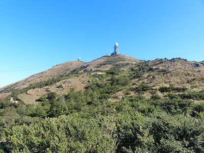
Radio transmitter at the top of Tai Mo Shan

I won't give you a detailed account of our hike (it started at the Tai Mo Shan lookout and ended along the Lam Kam Road in Lam Tsuen after descending via the Ng Tung Chai waterfalls) but thought there might be some people interested in the views, the nice weather and the winter covering of air pollution.

We were keen to shave a bit of time off the beginning of our trip by catching a taxi from Tsuen Wan West rail station (exit D for the taxi rank - cost around $80) to the upper car park next to the Tai Mo Shan lookout. If you have more time then it is easy to catch the #51 bus and ride to stop #12 (named "Country park") and walk back down to the entrance to the park at the bottom of Tai Mo Shan Road.

The view from the Tai Mo Shan Lookout is quite spectacular (in all honesty, the views are spectacular everywhere). The first picture below is looking north towards Kwun Yam Shan - that's the pointy hill in the centre. If you read my film locations blog then the view might be familiar, it's a similar angle anyway if not exact. The dip between Kwun Yam Shan and the next ridge line is the Lam Tsuen valley and beyond that into the haze is Fanling/Sheung Shui and Mainland China.

Kwun Yam Shan

Picture number two below, from the same vantage point, shows the view to the north west. On the far left is the runway at Sek Kong but just to its right is some of the construction work for the new high speed rail link to Guangzhou. The flat land around it is Pat Heung.

Sek Kong


The structure you can see above occupies the lower section of the lookout and was probably military given the mountain's strategic position and height. In fact the only reason getting here is so easy now is because of the former military-built roads that are still around such as Route Twisk and Tai Mo Shan Road. During the Japanese occupation, the Japanese military built a radar station up here and dug out a significant number of anti aircraft battery sites that can still be discerned in amongst the foliage. But first you have to wander off the road a little.


The bushes were buzzing at this time of years with thousands of bees. It was a bit disconcerting walking through them thinking we were walking into a bees nest only to see that the bees were just interested in the yellow flowers on the bushes. If anyone knows what the plant is then it would be interesting to find out.


No matter how far you wander away from the main road (there are small trails leading off all over the place) the radar station on top of the hill is always in view and looking in any other direction gave some really stunning views. In the case of the lower photo below this was looking south east and if you look carefully you can make out the silhouette of Lion Rock through the haze (hint: centre left).


The old Japanese battery sites are hidden in the undergrowth but actually fairly easy to spot. Much like in the old trenches we found at Ki Lun Shan, the dug-out ground here has acted like a catch water and often the plant growth inside outstrips the surrounding hillside in density and colour. Of course there are also the more obvious signs such as a berm at one side where a hillock has been used for natural protection. The pictures below actually show the same bunker. The berm is around 2 metres in height and as you can see from the lower picture provided a lot of cover from anyone looking over from the Tsuen Wan area. The whole area around the top of the mountain is covered in similar dug out defences and I believe they were used for AA guns. Some of the dug outs were bigger, some smaller, and one looks to have been used to house a generator.


If you get bored of looking out for old Japanese AA installations, then you can just shift your focus a bit further and see some familiar sights way down below. Such as the two temple complexes below.
The one on the left is Western Monastery (???) with its tall pagoda and just to the right you can see the smaller squat pagoda and concrete pai fong (ornamental gate) of the Yuen Yuen Institute (????). I did visit both these places during a trip a few years ago and I think it might be a good time to reinstate that post (it was on my old blog and has yet to be ported over to here).

Western Monastery and the Yuen Yuen Institute

A little over to the west and you can see Tsuen Wan town proper with the 'beard trimmer' shape of Nina Tower. Named after Nina Wang who controlled the Chinachem company until her death a few years ago.

Nina Tower and Tsuen Wan beyond the hill

Looking further to the north and you can make out the 'saddle' shape of Ma On Shan in the far distance. The next closest ridge line is the one that leads from Needle Hill to Grassy Hill (Grassy Hill is the highest bit on the left) which will be familiar to anyone who has walked Stage 7 of the Maclehose Trail. Look closely and you can see the trail itself as it comes down the side of Grassy Hill towards Leadmine Pass hidden in the dip.


The picture below shows another one of the Japanese bunkers but with the hazy image of Hong Kong Island's ridge line in the distance. The buildings that can be vaguely discerned on the right are the cluster of tall buildings at the tip of the West Kowloon reclamation including the ICC (far right).


After stumbling around in the wilderness for a couple of hours and finding all sorts of relics from the Japanese occupation, we headed back up to the road (Tai Mo Shan Road) and decided to follow it up to the summit and over to the north side of the mountain in order to head towards Tai Po. As you can see the road is (necessarily) windy. This section is off limits to private cars and is used as a service road for the various interested parties who need to come up here such as the AFCD (who look after the country park), the Observatory (they have radar and weather instrumentation here) and of course the PLA who have a communication station here. It's no problem for hikers though and indeed the Maclehose Trail incorporates this road into its route.


Sadly, actually reaching the summit is out of the question due to the aforementioned installations and this last photo above is not far from the top. Not being at the summit doesn't stop you from taking in the awesome scenery though.

Looking north east towards Tai Po and Tolo Harbour
Looking south towards Kowloon and Hong Kong Island
A distant view of the Kwun Yam Statue in north Tai Po

Pulling back from that close up the the Kwun Yam Statue at the Tsz Shan Monastery in Tai Po and you get the view below. Tai Po town is the cluster of white buildings on the left centre. But on the near slopes by the trail are what looks to be some old terraces that can still be seen.


I believe that these were once terraces for a small tea plantation that flourished for a time. The terraces are largely over grown now but we did notice that a few on the other side of the hill are being tended to once again but we didn't get close enough to be able to see what was being grown, although I understand that there are still tea plants here growing wild. It's quite easy to follow the road down here.


But it does eventually come to an abrupt end and just suddenly turns into a dirt track. It's at this point that you can continue along the trail and head towards Leadmine Pass or you can turn off towards the Ng Tung Chai waterfall trail and head down into the relatively cooler and shaded part of the lower slopes. The turn off is easy to spot because it's marked by a wooden shelter, although I'm not sure how permanent the cows are.

Cows enjoying the sparse shade on Tai Mo Shan

We were wondering if it was possible to access the Kadoorie farm complex from this trail. It is certainly marked on maps as though you can and you can even see the top part of the farm on Kwun Yam Shan from the trail (see below), but alas, they are obviously fed up with freeloaders using the trails as a free entry into the farm and have posted warning signs forbidding it upon pain of death (or perhaps something lesser), so we decided instead to just head down and see the waterfalls at Ng Tung Chai. But I'll save those for another post.

Dropping off point for the Kadoorie shuttle bus

Monday, November 28, 2016

Hongkong Around the Mai Po Marsh Nature Reserve History

The Mai Po Marsh Nature Reserve sits in the far northern reaches of Hong Kong's New Territories. It's not the easiest place to visit for two reasons 1. you need to pre-book onto a tour, no turning up on spec and 2. It is far away from the rail network which means you have to get there via taxi or green minibus. Luckily, it's been run by the WWF HK since 1983 and so all the information you require about it can be found by going to this page.

I did this the lazy way and just joined an organised trip done through my wife's work, but it was well worth taking the time. If you've ever visited the wetland park in Tin Shui Wai then this is more of the same but in a more natural environment (less boardwalk and more picturesque pathways) and I feel more worth the effort.

Mai Po Marsh Nature Reserve

The total area of the reserve covers around 2.5km by 1km and is bounded by the Frontier Closed Area border fence around one edge (it was actually still part of the FCA up until 2012). There's a fair amount of open space, but the walkable parts are limited to the edges of the various long ponds that stretch from one side of the reserve to the other in 100 metre (or so) steps. Theoretically you could spend a fair amount of time walking the length of these things but the WWF has (quite rightly given how uncontrollable some visitors can be) limited access to a few paths to various bird hides and to the perimeter. Still, you get a good feel for the place even if freedom of movement is steered somewhat.


Sadly, it was a bit drizzly and overcast on the day I went so I didn't get to see the area in its full sunny glory, but the marsh is quite impressive in any weather with its large swathes of mangrove, migratory birds and canal like waterways.


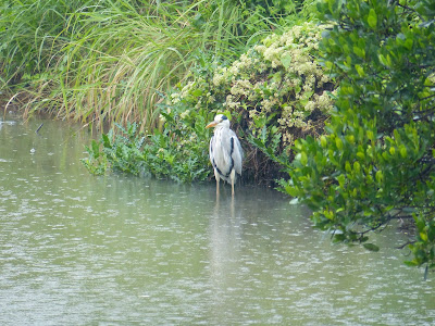
This place is also a haven for birds and the people who watch them and as a result there are several wooden hides constructed at strategic points to allow the ornithologically-minded to observe without disturbing the environment. However, being inside the hide isn't a prerequisite for seeing some of the local wildlife and we saw a fair amount of Great Cormorants. These guys were everywhere and usually high up in the tree tops. It turns out these particular birds migrate here from the colder north for the winter and hang around the wetlands (and surrounding waters of Shenzhen Bay) feeding on the fish before heading back home after winter.


Grey Heron

Birding aside, if you enjoy nature (and living in a place like Hong Kong certainly makes you appreciate it) then it is well worth the effort of organising a visit here and spending a few hours walking around the various pathways. The WWF also has a nature education centre which involves presentations and demonstrations detailing some of the flora and fauna. For example, while we were there we saw a presentation on the local population of fireflies.


It's frustrating. Having just heard the news that the HK Govt is about to stump up another HK$5 Billion for Disneyland whereas the WWF receives a minimal subsidy from the same Govt to maintain the nature reserve, you begin to understand the way the Govt here works. It sees little to no value in ecological attractions such as this and, if anything, consider them a barrier to further redevelopment. So I shall leave you with some nice pictures to try and encourage you to go there yourself (and take better pictures).


In case you are wondering what fate this place might have in store for it in the future take a look at the following picture. The whole border region was once similar to Mai Po - fertile agricultural land used for rice growing a fish/prawn farming. Just within the last 30 years the Chinese side (Shenzhen) has developed into a mega metropolis whilst the HK-side has remained undeveloped. Let's hope it stays that way.

Beauty and the beast